IMAGES TAKEN NEAR TO
Liverpool Road, ORMSKIRK, L39 0EG
Introduction
This page details the photographs taken nearby to Liverpool Road, L39 0EG by members of the Geograph project.
The Geograph project started in 2005 with the aim of publishing, organising and preserving representative images for every square kilometre of Great Britain, Ireland and the Isle of Man.

There are currently over 7.5m images from over14,400 individuals and you can help contribute to the project by visiting https://www.geograph.org.uk
Image Map
Images are licensed for reuse under creativecommons.org/licenses/by-sa/2.0
Notes
- Clicking on the map will re-center to the selected point.
- The higher the marker number, the further away the image location is from the centre of the postcode.
Image Listing (18 Images Found)
Images are licensed for reuse under creativecommons.org/licenses/by-sa/2.0
Image
Details
Distance
2
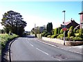
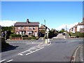
Topiary on Liverpool Road
This beautiful garden is near the junction of Church Road
Image: © Raymond Knapman
Taken: 6 Oct 2010
0.08 miles
4
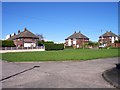
The green square at Heyescroft
This small housing estate near Stanley Gate has its own square
Image: © Raymond Knapman
Taken: 6 Oct 2010
0.16 miles
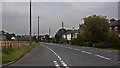
6
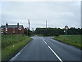
Church Road joins Liverpool Road near Stanley Gate
Image: © Raymond Knapman
Taken: 6 Oct 2010
0.18 miles
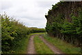
7
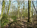
Path through Ox Hey Plantation
Alongside the M58 near Bickerstaffe
Image: © Gary Rogers
Taken: 4 Mar 2015
0.19 miles
9
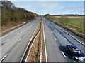
M58 between Ox Hey Field and Ox Hey Plantation
Image: © Gary Rogers
Taken: 4 Mar 2015
0.21 miles
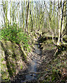
10
Footpath off Church Road
The Old Windmill is well hidden
Image: © Ian Greig
Taken: 9 Jul 2011
0.22 miles