IMAGES TAKEN NEAR TO
Liverpool Road, ORMSKIRK, L39 0EE
Introduction
This page details the photographs taken nearby to Liverpool Road, L39 0EE by members of the Geograph project.
The Geograph project started in 2005 with the aim of publishing, organising and preserving representative images for every square kilometre of Great Britain, Ireland and the Isle of Man.

There are currently over 7.5m images from over14,400 individuals and you can help contribute to the project by visiting https://www.geograph.org.uk
Image Map
Images are licensed for reuse under creativecommons.org/licenses/by-sa/2.0
Notes
- Clicking on the map will re-center to the selected point.
- The higher the marker number, the further away the image location is from the centre of the postcode.
Image Listing (10 Images Found)
Images are licensed for reuse under creativecommons.org/licenses/by-sa/2.0
Image
Details
Distance
1
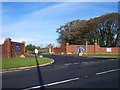
Entrance to Mossock Hall Golf Club on Liverpool Road
Image: © Raymond Knapman
Taken: 15 Nov 2010
0.15 miles
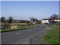
2
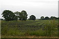
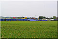
Fields at Royal Oak, near Bickerstaffe
Image: © Mike Pennington
Taken: 6 Jul 2015
0.19 miles
3
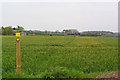
Footpath between Cunscough Lane and Bowker's Green Lane
Image: © Gary Rogers
Taken: 30 Apr 2017
0.20 miles
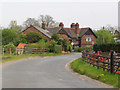
4
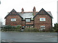
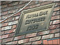
Royal Oak Cottages
Located on the corner of Liverpool Road and Simonswood Lane
Image: © Peter Hodge
Taken: 29 Dec 2005
0.21 miles
6
Laying new gas pipeline near Royal Oak Farm, Bowker's Green Lane, Aughton
Image: © Gary Rogers
Taken: 30 Apr 2017
0.21 miles
7
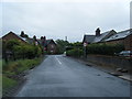
Bowkers Green Lane approaching Liverpool Road junction
Image: © Colin Pyle
Taken: 30 May 2011
0.21 miles
8
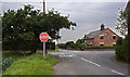
The end of Simonswood Lane
Bowkers Green Lane opposite across Liverpool Road
Image: © Ian Greig
Taken: 16 Sep 2011
0.22 miles
10
Royal Oak, Bowker's Green Lane, Aughton
Image: © Gary Rogers
Taken: 30 Apr 2017
0.23 miles