IMAGES TAKEN NEAR TO
Page Walk, LIVERPOOL, L3 8DZ
Introduction
This page details the photographs taken nearby to Page Walk, L3 8DZ by members of the Geograph project.
The Geograph project started in 2005 with the aim of publishing, organising and preserving representative images for every square kilometre of Great Britain, Ireland and the Isle of Man.

There are currently over 7.5m images from over14,400 individuals and you can help contribute to the project by visiting https://www.geograph.org.uk
Image Map
Images are licensed for reuse under creativecommons.org/licenses/by-sa/2.0
Notes
- Clicking on the map will re-center to the selected point.
- The higher the marker number, the further away the image location is from the centre of the postcode.
Image Listing (17 Images Found)
Images are licensed for reuse under creativecommons.org/licenses/by-sa/2.0
Image
Details
Distance
1
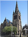
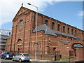
St Francis Xavier's Church
Once the largest Roman Catholic Parish in England with over 13,000 parishioners, the Church of Saint Francis Xavier (SFX) is a magnificent Grade 2* listed building designed by J.J. Scholes. The original St Francis Xavier's opened its doors on 4th December 1848, staffed by the Society of Jesus (Jesuits). Jesuits had been working in the Liverpool area since the C17th and in 1712, built the city's first Catholic Chapel since the Reformation.
http://www.sfxchurchliverpool.com/history/historymain.php
Image: © Sue Adair
Taken: 2 Jul 2011
0.14 miles
2
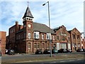
Liverpool City fire station
Liverpool City fire station, St Anne Street, Liverpool
Image: © Kevin Hale
Taken: 27 May 2010
0.16 miles
3
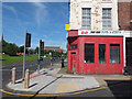
Ho Ho Fish and Chips
Junction of Stafford Street and Islington, Liverpool 3
Image: © Gary Rogers
Taken: 17 Jul 2016
0.17 miles
4
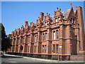
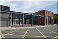
St Francis Xavier's (SFX) College
Built in 1843 St Francis Xavier's (SFX) College was the first Catholic Secondary Grammar Day School in the country. This second building in Salisbury Street was designed by Henry Clutton and opened in 1877. In the 1960's the College moved to new premises in Woolton and the building was abandoned until recently when the grade II listed building was taken over by Hope University.
Image: © Sue Adair
Taken: 2 Jul 2011
0.19 miles
5
Ghost sign, St Anne Street
See Image for more information
Image: © Graham Hogg
Taken: 24 Mar 2014
0.19 miles
6
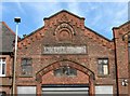
Clock tower, St Anne Street
The clock tower is on the building occupied by Henry Willis and sons. The adjacent premises are the former premises of L. Keizer Co. Ltd and the name remains as a ghost sign http://www.geograph.org.uk/photo/3907049 below the datestone of 1876. In 1842 L Keizer & Co were "Carvers & Gilders, Looking Glass & Clock Makers & Dealers in
Plate Glass". http://www.nationalarchives.gov.uk/nra/onlinelists/GB%200136%20B-KV.pdf
Image: © Graham Hogg
Taken: 24 Mar 2014
0.19 miles
7
St Mary of the Angels Roman Catholic Church
The former St Mary of the Angels, founded in 1909. It was funded by Amy Elizabeth Imrie, a Catholic convert and nun who became Abbess of the Poor Clare Sisters and was heiress to the White Star Line shipping fortune.
It is a Grade II Listed Building and was closed in 2001 by the Roman Catholic Archdiocese of Liverpool but was prevented from stripping the church's listed Italian High Renaissance-style marble interior fixtures and fittings. Since 2006 it has become a rehearsal space for the Royal Liverpool Philharmonic Orchestra.
Image: © Sue Adair
Taken: 20 Aug 2019
0.20 miles
8
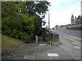
Ramp to pedestrian subway, St Anne Street, Liverpool
Image: © Richard Vince
Taken: 29 Jun 2022
0.20 miles