IMAGES TAKEN NEAR TO
Orrell Hill Lane, LIVERPOOL, L38 5DA
Introduction
This page details the photographs taken nearby to Orrell Hill Lane, L38 5DA by members of the Geograph project.
The Geograph project started in 2005 with the aim of publishing, organising and preserving representative images for every square kilometre of Great Britain, Ireland and the Isle of Man.

There are currently over 7.5m images from over14,400 individuals and you can help contribute to the project by visiting https://www.geograph.org.uk
Image Map
Images are licensed for reuse under creativecommons.org/licenses/by-sa/2.0
Notes
- Clicking on the map will re-center to the selected point.
- The higher the marker number, the further away the image location is from the centre of the postcode.
Image Listing (17 Images Found)
Images are licensed for reuse under creativecommons.org/licenses/by-sa/2.0
Image
Details
Distance
3
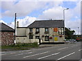
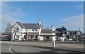
Weld Blundell Public House, Ince Blundell
An old pub on the road from Liverpool to Southport and beyond, along the Sefton coast. Blundell and Weld-Blundell are family names of aristocracy from this area. SD317038
Image: © Keith Williamson
Taken: 5 Aug 2005
0.03 miles
6
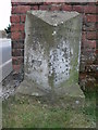
Old Milestone by the A565, Tristram's Farm, Ince Blundell
Carved stone post by the A565/Lady Green Lane junction, in parish of INCE BLUNDELL (SEFTON District), Lady Green, Tristram's Farm, by the road, on West side of minor road. Lancs CC stone triangle, erected by the County Council in the 19th/20th century, moved from its original location, which was further south east.
Inscription reads:-
: TO / LIVERPOOL / 10 MILES : : INCE BLUNDELL : : TO / SOUTHPORT / 10½ MILES :
Merseyside HER listed. https://www.heritagegateway.org.uk/Gateway/Results_Single.aspx?uid=3314264&resourceID=1970
Milestone Society National ID: LA_LVSP10.
Image: © J Higgins
Taken: 1 Sep 2008
0.06 miles
7
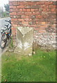
Old Milestone by the A565, Tristram's Farm, Ince Blundell
Carved stone post by the A565/Lady Green Lane junction, in parish of Ince Blundell (Sefton District), Lady Green, Tristram's Farm, by the road, on West side of minor road. Lancs CC stone triangle, erected by the County Council in the 19th/20th century, moved from its original location, which was further southeast. An earlier photograph can be found here https://www.geograph.org.uk/photo/6035625.
Inscription reads:-
: TO / LIVERPOOL / 10 MILES : : INCE BLUNDELL : : TO / SOUTHPORT / 10½ MILES :
Merseyside HER listed. https://www.heritagegateway.org.uk/Gateway/Results_Single.aspx?uid=3314264&resourceID=1970
Milestone Society National ID: LA_LVSP10
Image: © Nigel Upton
Taken: 16 Apr 2023
0.06 miles
8
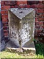
Milestone Ince Blundell
This milestone is midway between Liverpool and Southport.
Image: © Norman Caesar
Taken: 26 May 2012
0.06 miles
9
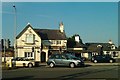
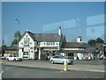
Weld Blundell, Ince Blundell
Pub along the A565.
Image: © Mike Pennington
Taken: 1 Aug 2013
0.06 miles
10
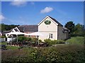
The Red Squirrel Harvester Pub on the A565
Image: © Raymond Knapman
Taken: 8 Aug 2012
0.06 miles