IMAGES TAKEN NEAR TO
Moss Lane, LIVERPOOL, L38 3RA
Introduction
This page details the photographs taken nearby to Moss Lane, L38 3RA by members of the Geograph project.
The Geograph project started in 2005 with the aim of publishing, organising and preserving representative images for every square kilometre of Great Britain, Ireland and the Isle of Man.

There are currently over 7.5m images from over14,400 individuals and you can help contribute to the project by visiting https://www.geograph.org.uk
Image Map (6 Images)
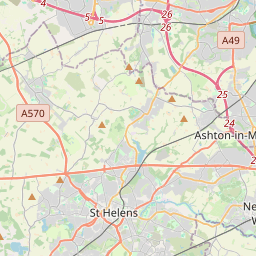

Leaflet Map data © OpenStreetMap
Images are licensed for reuse under creativecommons.org/licenses/by-sa/2.0
Notes
- Clicking on the map will re-center to the selected point.
- The higher the marker number, the further away the image location is from the centre of the postcode.
Image Listing (6 Images Found)
Images are licensed for reuse under creativecommons.org/licenses/by-sa/2.0
Image
Details
Distance
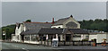

3
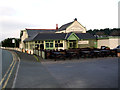
The Pheasant
This was once a country pub, now it's a restaurant!
Image: © Norman Caesar
Taken: 15 Nov 2011
0.09 miles
4
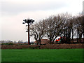
Mobile Phone transmitter mast
This mast has been cleverly disguised as a tree
Image: © Norman Caesar
Taken: 15 Nov 2011
0.20 miles