IMAGES TAKEN NEAR TO
Riverside, LIVERPOOL, L38 0BU
Introduction
This page details the photographs taken nearby to Riverside, L38 0BU by members of the Geograph project.
The Geograph project started in 2005 with the aim of publishing, organising and preserving representative images for every square kilometre of Great Britain, Ireland and the Isle of Man.

There are currently over 7.5m images from over14,400 individuals and you can help contribute to the project by visiting https://www.geograph.org.uk
Image Map
Images are licensed for reuse under creativecommons.org/licenses/by-sa/2.0
Notes
- Clicking on the map will re-center to the selected point.
- The higher the marker number, the further away the image location is from the centre of the postcode.
Image Listing (58 Images Found)
Images are licensed for reuse under creativecommons.org/licenses/by-sa/2.0
Image
Details
Distance
1
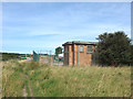
Pumping Station near the River Alt at Hightown
Image: © Gary Rogers
Taken: 13 Aug 2017
0.06 miles
2
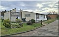
Biodiversity Outdoor Activity Centre
Sefton Council
Image: © Chris Morgan
Taken: 2 Feb 2023
0.08 miles
3
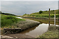
The River Alt
The Alt runs from Huyton at 38m, through Croxteth Park, roughly follows the M57 motorway south of Kirkby, then flows north of Aintree and south of Maghull. It then runs south of Formby and empties into the Irish Sea, near the edge of the Mersey estuary here at Hightown.
Image: © Ian Greig
Taken: 10 Jun 2016
0.08 miles
4
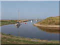
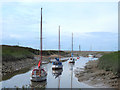
Yachts moored in the River Alt
The web pages for Blundellsands Sailing Club http://homepages.rya-online.net/blundellsandssailingclub/ which operates from here describe it as "a muddy tributary of the River Mersey with a somewhat tortuous entrance".
Image: © David Hawgood
Taken: 29 Apr 2007
0.09 miles
5
Near the mouth of the River Alt at Hightown
Image: © Gary Rogers
Taken: 13 Aug 2017
0.10 miles
7
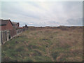
Hightown on the dunes
These houses are literally built on reclaimed dunes. The footpath runs north to south and the pic is taken looking south. Vegetation is well established here and willows and prickly gorse-like bushes grow well.
Image: © Gary Rogers
Taken: 4 Apr 2005
0.11 miles
8
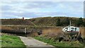
Lookout post on Altcar Rifle Range
River Alt in the foreground.
Image: © Mike Pennington
Taken: 19 Nov 2015
0.12 miles
9
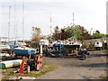
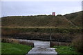
Boat yard, Hightown
This is the laying up yard of Blundellsands Sailing Club, see their website http://homepages.rya-online.net/blundellsandssailingclub/infopack.htm for information about the club which sails from the Alt estuary.
Image: © David Hawgood
Taken: 29 Apr 2007
0.12 miles
10
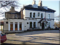
The Hightown Hotel
This hotel is reputed to have been built with stone from the demolished Kirkdale Jail
Image: © Norman Caesar
Taken: 6 Feb 2013
0.14 miles