IMAGES TAKEN NEAR TO
Burlington Avenue, LIVERPOOL, L37 8DY
Introduction
This page details the photographs taken nearby to Burlington Avenue, L37 8DY by members of the Geograph project.
The Geograph project started in 2005 with the aim of publishing, organising and preserving representative images for every square kilometre of Great Britain, Ireland and the Isle of Man.

There are currently over 7.5m images from over14,400 individuals and you can help contribute to the project by visiting https://www.geograph.org.uk
Image Map
Images are licensed for reuse under creativecommons.org/licenses/by-sa/2.0
Notes
- Clicking on the map will re-center to the selected point.
- The higher the marker number, the further away the image location is from the centre of the postcode.
Image Listing (13 Images Found)
Images are licensed for reuse under creativecommons.org/licenses/by-sa/2.0
Image
Details
Distance
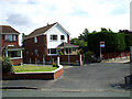
1
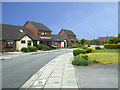
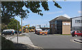
A Pleasing Extension to Bull Cop Formby
This development was added to the Eastern end of Bull Cop in the early 1990s.
Image: © stan lewis
Taken: 18 Apr 2008
0.10 miles
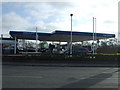
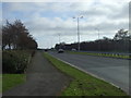
2
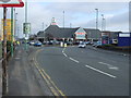
Junction of the B5165 with the A565 Formby by-pass
Image: © Mike Pennington
Taken: 6 Aug 2014
0.14 miles
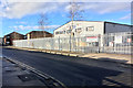
4
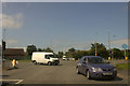
An industrial estate at Formby
Where to hire your heavy plant
Image: © Ian Greig
Taken: 22 Jul 2016
0.14 miles
8
Entrance to Cattan Green from Shaw Crescent
A side entrance to Cattan Green from Shaw Crescent.e
Image: © stan lewis
Taken: 27 Aug 2010
0.20 miles
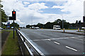
9
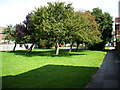
Cattan Green Formby
A pleasant area amongst houses.
Image: © stan lewis
Taken: 27 Aug 2010
0.21 miles