IMAGES TAKEN NEAR TO
Hawksworth Close, LIVERPOOL, L37 7EX
Introduction
This page details the photographs taken nearby to Hawksworth Close, L37 7EX by members of the Geograph project.
The Geograph project started in 2005 with the aim of publishing, organising and preserving representative images for every square kilometre of Great Britain, Ireland and the Isle of Man.

There are currently over 7.5m images from over14,400 individuals and you can help contribute to the project by visiting https://www.geograph.org.uk
Image Map
Images are licensed for reuse under creativecommons.org/licenses/by-sa/2.0
Notes
- Clicking on the map will re-center to the selected point.
- The higher the marker number, the further away the image location is from the centre of the postcode.
Image Listing (10 Images Found)
Images are licensed for reuse under creativecommons.org/licenses/by-sa/2.0
Image
Details
Distance
4
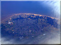
Formby from the air
Enjoying a localised break in the clouds which covered most of the rest of the north of England.
Image: © Thomas Nugent
Taken: 21 Mar 2011
0.15 miles
5
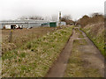
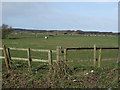
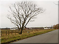
Formby, Eight Acre Lane
Track between the Formby Bypass (A565) and Southport Old Road.
Image: © David Dixon
Taken: 23 Feb 2013
0.16 miles
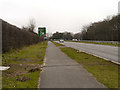
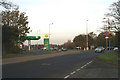
7
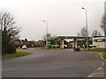
BP Garage, Formby Bypass
BP filling station on the roundabout at the junction of Southport Road with the A565, Formby Bypass.
Image: © David Dixon
Taken: 23 Feb 2013
0.20 miles
10
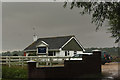
Formby, Rose Farm
Rose Farm on Southport Old Road.
Image: © David Dixon
Taken: 23 Feb 2013
0.25 miles