IMAGES TAKEN NEAR TO
Liverpool Road, LIVERPOOL, L37 6BU
Introduction
This page details the photographs taken nearby to Liverpool Road, L37 6BU by members of the Geograph project.
The Geograph project started in 2005 with the aim of publishing, organising and preserving representative images for every square kilometre of Great Britain, Ireland and the Isle of Man.

There are currently over 7.5m images from over14,400 individuals and you can help contribute to the project by visiting https://www.geograph.org.uk
Image Map
Images are licensed for reuse under creativecommons.org/licenses/by-sa/2.0
Notes
- Clicking on the map will re-center to the selected point.
- The higher the marker number, the further away the image location is from the centre of the postcode.
Image Listing (12 Images Found)
Images are licensed for reuse under creativecommons.org/licenses/by-sa/2.0
Image
Details
Distance
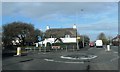
4
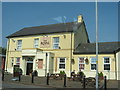
Thatched House, Little Altcar, Merseyside
Situated in Little Altcar, close to Formby, this house provides a striking contrast to others hereabouts and is a local landmark.
Image: © Keith Williamson
Taken: 5 Aug 2005
0.16 miles
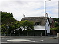
5
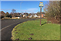
Little Altcar
Village entrance sign at the side of Liverpool Road. Little Altcar is a village (population 910 at the 2011 census) which has become merged with the town of Formby. The name Altcar derives from Norse, meaning "marsh by the River Alt".
Image: © David Dixon
Taken: 17 Feb 2018
0.16 miles
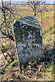
7
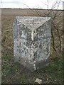
Old Milestone by the B5424, Liverpool Road, Little Altcar Parish
Carved stone post by the B5424, in parish of LITTLE ALTCAR (SEFTON District), Liverpool Road, 200m West of the roundabout, on verge, on South side of road. Lancashire CC stone triangle, erected by the Local Highways Board in the 19th/20th century.
Inscription reads:- : SOUTHPORT / 8½ MILES : : SOUTHPORT DISTRICT / HIGHWAY / BOARD : : LIVERPOOL / 12 MILES :
Milestone Society National ID: LA_LVSP12.
Image: © J Higgins
Taken: 1 Sep 2008
0.20 miles
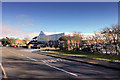
8
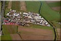
Formby Industrial Estate 1981
The large red building is Woodwards, now Tesco.
Image: © ROB FOSTER
Taken: 1 May 1981
0.20 miles
9
Mile Stone on Liverpool Road at Little Altcar
Mile stone at the side of Liverpool Road (B5424) reads Southport 8½ miles (the other side says Liverpool 12 miles).
Image: © David Dixon
Taken: 17 Feb 2018
0.22 miles
10
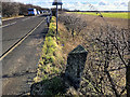
Little Altcar, Milestone on Liverpool Road
Mile stone at the side of Liverpool Road (B5424) reads Liverpool 12 miles (Image] is a closer look at the mile stone taken from the opposite side where it says Southport 8½ miles).
Image: © David Dixon
Taken: 17 Feb 2018
0.22 miles