IMAGES TAKEN NEAR TO
Park Close, LIVERPOOL, L37 6AP
Introduction
This page details the photographs taken nearby to Park Close, L37 6AP by members of the Geograph project.
The Geograph project started in 2005 with the aim of publishing, organising and preserving representative images for every square kilometre of Great Britain, Ireland and the Isle of Man.

There are currently over 7.5m images from over14,400 individuals and you can help contribute to the project by visiting https://www.geograph.org.uk
Image Map
Images are licensed for reuse under creativecommons.org/licenses/by-sa/2.0
Notes
- Clicking on the map will re-center to the selected point.
- The higher the marker number, the further away the image location is from the centre of the postcode.
Image Listing (27 Images Found)
Images are licensed for reuse under creativecommons.org/licenses/by-sa/2.0
Image
Details
Distance
1
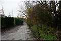
Far end of Hoggs Hill Lane, Formby
The railway line is at the end of this section.
Image: © Mike Pennington
Taken: 19 Nov 2015
0.03 miles
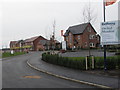
2
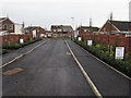
New access road from Hoggs Hill Lane to Park Road, Formby
127 and 129 Park Road have been demolished to provide this access to the large new housing estate "Orchid Meadow" on the site of the former railway powerhouse.
Image: © David Hawgood
Taken: 26 Dec 2014
0.03 miles
3
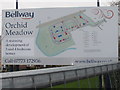
Map of Formby powerhouse site as Orchid Meadow
This Bellway signboard shows how new streets are being laid out in a development of three and four bedroom houses on the site of the powerhouse which supplied electricity to the Liverpool-Southport railway. The River Alt curves around the left of the map - the south. The railway is at the top, Hoggs Hill Lane is on the right with an access road going through the site of the demolished 127 and 129 Park Road to give road access to Formby.
Image: © David Hawgood
Taken: 26 Dec 2014
0.03 miles
5
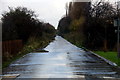
Orchid Meadow housing estate
A new development of 3 and 4 bedroom houses on the site of the former railway powerhouse.
Image: © David Hawgood
Taken: 26 Dec 2014
0.06 miles
7
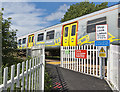
Level Crossing
This is what you're looking and listening for
Image: © Ian Greig
Taken: 24 Jun 2016
0.06 miles
8
Level Crossing
In the same minute (on the camera) that I took this I took two further shots of a passing train, the second being the rear of it. I had not seen or heard the train when taking this so one would be well advised to take heed of the notice.
Image: © Ian Greig
Taken: 24 Jun 2016
0.06 miles
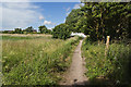
9
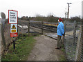
Pedestrian level crossing, Altcar
The crossing provides a footpath from Formby to paths beside the Altcar rifle ranges and alongside the railway.
Image: © David Hawgood
Taken: 26 Dec 2014
0.07 miles
10
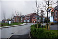
New housing on the south side of Formby
The area still marked as 'works' on most current maps (but long vacant) has now changed. The old factory has been replaced by a new housing scheme, apparently named Orchid Meadow.
Image: © Mike Pennington
Taken: 19 Nov 2015
0.08 miles