IMAGES TAKEN NEAR TO
Redgate, LIVERPOOL, L37 4EP
Introduction
This page details the photographs taken nearby to Redgate, L37 4EP by members of the Geograph project.
The Geograph project started in 2005 with the aim of publishing, organising and preserving representative images for every square kilometre of Great Britain, Ireland and the Isle of Man.

There are currently over 7.5m images from over14,400 individuals and you can help contribute to the project by visiting https://www.geograph.org.uk
Image Map
Images are licensed for reuse under creativecommons.org/licenses/by-sa/2.0
Notes
- Clicking on the map will re-center to the selected point.
- The higher the marker number, the further away the image location is from the centre of the postcode.
Image Listing (8 Images Found)
Images are licensed for reuse under creativecommons.org/licenses/by-sa/2.0
Image
Details
Distance
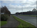
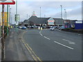
2
Junction of the B5165 with the A565 Formby by-pass
Image: © Mike Pennington
Taken: 6 Aug 2014
0.16 miles
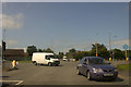
5
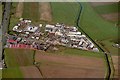
Formby Industrial Estate 1981
The large red building is Woodwards, now Tesco.
Image: © ROB FOSTER
Taken: 1 May 1981
0.20 miles
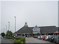
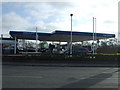
8
Tesco Formby Superstore
Tesco's Formby store on Altcar Road, just to the east of the Formby by-pass.
Image: © David Dixon
Taken: 17 Feb 2018
0.23 miles