IMAGES TAKEN NEAR TO
Watchyard Lane, LIVERPOOL, L37 3JX
Introduction
This page details the photographs taken nearby to Watchyard Lane, L37 3JX by members of the Geograph project.
The Geograph project started in 2005 with the aim of publishing, organising and preserving representative images for every square kilometre of Great Britain, Ireland and the Isle of Man.

There are currently over 7.5m images from over14,400 individuals and you can help contribute to the project by visiting https://www.geograph.org.uk
Image Map
Images are licensed for reuse under creativecommons.org/licenses/by-sa/2.0
Notes
- Clicking on the map will re-center to the selected point.
- The higher the marker number, the further away the image location is from the centre of the postcode.
Image Listing (7 Images Found)
Images are licensed for reuse under creativecommons.org/licenses/by-sa/2.0
Image
Details
Distance
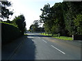
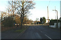
2
Junction of Moss Side with the Formby By-pass (A565)
Image: © JThomas
Taken: 15 Mar 2014
0.21 miles
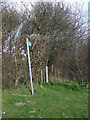
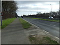
3
Major road ahead - the A565 Formby by-pass
Image: © David Long
Taken: 12 Dec 2005
0.21 miles
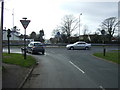
4
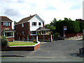
Entrance to Cattan Green from Shaw Crescent
A side entrance to Cattan Green from Shaw Crescent.e
Image: © stan lewis
Taken: 27 Aug 2010
0.21 miles
5
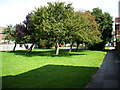
Cattan Green Formby
A pleasant area amongst houses.
Image: © stan lewis
Taken: 27 Aug 2010
0.21 miles