IMAGES TAKEN NEAR TO
Tadlow Close, LIVERPOOL, L37 2YZ
Introduction
This page details the photographs taken nearby to Tadlow Close, L37 2YZ by members of the Geograph project.
The Geograph project started in 2005 with the aim of publishing, organising and preserving representative images for every square kilometre of Great Britain, Ireland and the Isle of Man.

There are currently over 7.5m images from over14,400 individuals and you can help contribute to the project by visiting https://www.geograph.org.uk
Image Map
Images are licensed for reuse under creativecommons.org/licenses/by-sa/2.0
Notes
- Clicking on the map will re-center to the selected point.
- The higher the marker number, the further away the image location is from the centre of the postcode.
Image Listing (6 Images Found)
Images are licensed for reuse under creativecommons.org/licenses/by-sa/2.0
Image
Details
Distance
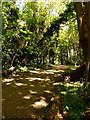
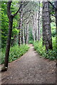
3
Path through the woods near St Luke's Church Road, Formby
Image: © Mike Pennington
Taken: 2 Jul 2015
0.17 miles
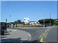
5
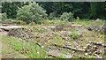
Firwood House, Raven Meols
These are the remains of Firwood House. Built in the mid 19th Century and once owned by a Dr Richard Formby the house was ruined in the 1970's and was subsequently demolished.
Image: © Gary Rogers
Taken: 27 Jun 2009
0.19 miles
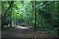
6
Path through pinewoods near Albert Road, Formby
Image: © Mike Pennington
Taken: 2 Jul 2015
0.20 miles