IMAGES TAKEN NEAR TO
Brooks Way, LIVERPOOL, L37 2JP
Introduction
This page details the photographs taken nearby to Brooks Way, L37 2JP by members of the Geograph project.
The Geograph project started in 2005 with the aim of publishing, organising and preserving representative images for every square kilometre of Great Britain, Ireland and the Isle of Man.

There are currently over 7.5m images from over14,400 individuals and you can help contribute to the project by visiting https://www.geograph.org.uk
Image Map
Images are licensed for reuse under creativecommons.org/licenses/by-sa/2.0
Notes
- Clicking on the map will re-center to the selected point.
- The higher the marker number, the further away the image location is from the centre of the postcode.
Image Listing (14 Images Found)
Images are licensed for reuse under creativecommons.org/licenses/by-sa/2.0
Image
Details
Distance
1
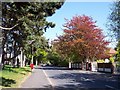
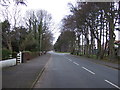
Kirklake Road Formby
Copper coloured trees glow in the spring sunshine
Image: © Raymond Knapman
Taken: 28 Apr 2011
0.06 miles
2
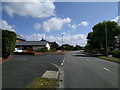
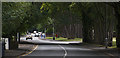
On Bushby's Lane at the corner of Bushby's Park, looking east
Image: © Rob Purvis
Taken: 8 Aug 2016
0.07 miles
3
St Luke's Church Hall, Formby
On Kirklake Road.
Image: © JThomas
Taken: 15 Mar 2014
0.08 miles
4
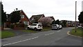
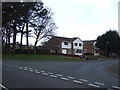
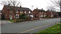
Houses in Langdale Avenue
A view of typical housing in this area of Formby.
Image: © Peter Mackenzie
Taken: 16 Mar 2017
0.13 miles
6
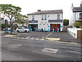
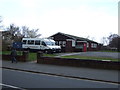
Formby Co-op
This convenience store is in Queens Road.
Image: © David Hawgood
Taken: 1 May 2017
0.16 miles
8
Turf zone KirklakeRoad
Green on Kirklake Road, Formby.
Image: © Ian S
Taken: 16 Jun 2023
0.20 miles
9
Local Authority Housing
Typical Local Authority housing stock in Formby.
Image: © Peter Mackenzie
Taken: 16 Mar 2017
0.20 miles