IMAGES TAKEN NEAR TO
Cambridge Road, LIVERPOOL, L37 2EL
Introduction
This page details the photographs taken nearby to Cambridge Road, L37 2EL by members of the Geograph project.
The Geograph project started in 2005 with the aim of publishing, organising and preserving representative images for every square kilometre of Great Britain, Ireland and the Isle of Man.

There are currently over 7.5m images from over14,400 individuals and you can help contribute to the project by visiting https://www.geograph.org.uk
Image Map
Images are licensed for reuse under creativecommons.org/licenses/by-sa/2.0
Notes
- Clicking on the map will re-center to the selected point.
- The higher the marker number, the further away the image location is from the centre of the postcode.
Image Listing (8 Images Found)
Images are licensed for reuse under creativecommons.org/licenses/by-sa/2.0
Image
Details
Distance
1
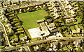
St Luke's School 1981
One of 100s of aerial photographs I have of North Merseyside.
Image: © ROB FOSTER
Taken: 1 May 1981
0.12 miles
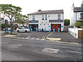
2
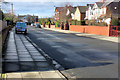
Elson Road
A residential road in Formby, a dormitory town for nearby Liverpool.
Image: © David Dixon
Taken: 17 Feb 2018
0.15 miles
3
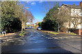
Formby, Foster Road
A tree-lined residential road in Formby, a dormitory town for nearby Liverpool.
Image: © David Dixon
Taken: 17 Feb 2018
0.20 miles
4
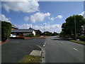
On Bushby's Lane at the corner of Bushby's Park, looking east
Image: © Rob Purvis
Taken: 8 Aug 2016
0.21 miles
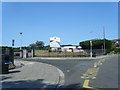
6
Formby Co-op
This convenience store is in Queens Road.
Image: © David Hawgood
Taken: 1 May 2017
0.24 miles
7
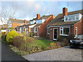
Beechwood Drive, Formby
Bright sunshine on Christmas Day.
Image: © David Hawgood
Taken: 25 Dec 2014
0.25 miles
8
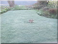
Wild rabbit on urban lawn
On a frosty morning the rabbit was on the lawn eating grass.
Image: © David Hawgood
Taken: 17 Apr 2016
0.25 miles