IMAGES TAKEN NEAR TO
Montagu Road, LIVERPOOL, L37 1LB
Introduction
This page details the photographs taken nearby to Montagu Road, L37 1LB by members of the Geograph project.
The Geograph project started in 2005 with the aim of publishing, organising and preserving representative images for every square kilometre of Great Britain, Ireland and the Isle of Man.

There are currently over 7.5m images from over14,400 individuals and you can help contribute to the project by visiting https://www.geograph.org.uk
Image Map
Images are licensed for reuse under creativecommons.org/licenses/by-sa/2.0
Notes
- Clicking on the map will re-center to the selected point.
- The higher the marker number, the further away the image location is from the centre of the postcode.
Image Listing (9 Images Found)
Images are licensed for reuse under creativecommons.org/licenses/by-sa/2.0
Image
Details
Distance
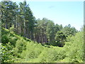
2
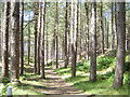
Woodland path in Ainsdale Nature Reserve
Image: © marplerambler
Taken: 4 Jun 2011
0.16 miles
3
Formby Golf Club from Woodland Path
At this point, the Woodland Path comes right to the green of a hole of Formby Golf Club. Formby Golf Club is unique in Britain not because membership is solely for men but because Formby Ladies Golf Club, founded in 1896, is located on the same links. The Ladies Club is completely independent with its own Clubhouse and greenkepers, the superb championship Ladies course is enclosed within the men's course.
Image: © Sue Adair
Taken: 29 Jun 2006
0.16 miles
4
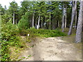
Marker post on the Inner Woodland Path
The path is part of the Sefton Coastal Footpath through Ainsdale Nature Reserve
Image: © Raymond Knapman
Taken: 18 Aug 2015
0.17 miles
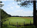
5
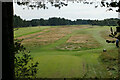
Formby Golf Club
A view from the Sefton Coastal Footpath at the northern end of the course.
Image: © Bill Boaden
Taken: 18 Sep 2021
0.23 miles
6
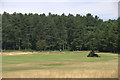
Formby Golf Course
The northernmost holes, north of public footpath known as the Fisherman's Path.
Image: © Mike Pennington
Taken: 1 Aug 2013
0.24 miles
7
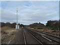
Train Track from The Fisherman's Path
Image: © Anthony Parkes
Taken: 15 Feb 2013
0.24 miles
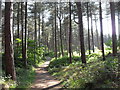
8
Looking West on Woodland Path
Looking West on Woodland Path in the Ainsdale Sand Dunes National Nature Reserve. These pines were all planted in the last century and are now mature. Some areas along this path have been cleared of pines and the broadleaf trees have been allowed to grow.
Image: © Sue Adair
Taken: 29 Jun 2006
0.24 miles
9
Remains of WWII Bunker near Fisherman's Path
Image: © Gary Rogers
Taken: 11 Sep 2016
0.24 miles