IMAGES TAKEN NEAR TO
Southport Old Road, LIVERPOOL, L37 0AB
Introduction
This page details the photographs taken nearby to Southport Old Road, L37 0AB by members of the Geograph project.
The Geograph project started in 2005 with the aim of publishing, organising and preserving representative images for every square kilometre of Great Britain, Ireland and the Isle of Man.

There are currently over 7.5m images from over14,400 individuals and you can help contribute to the project by visiting https://www.geograph.org.uk
Image Map
Images are licensed for reuse under creativecommons.org/licenses/by-sa/2.0
Notes
- Clicking on the map will re-center to the selected point.
- The higher the marker number, the further away the image location is from the centre of the postcode.
Image Listing (40 Images Found)
Images are licensed for reuse under creativecommons.org/licenses/by-sa/2.0
Image
Details
Distance
1
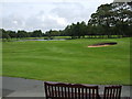
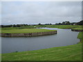
The main course viewed from the restaurant
Sit and enjoy the view.
Image: © stan lewis
Taken: 31 Jul 2008
0.04 miles
2
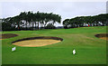
Test bunkers
Try these out before you start your round.
Image: © stan lewis
Taken: 31 Jul 2008
0.11 miles
3

Part of the new par three nine hole.
View from the second tee.
Image: © stan lewis
Taken: 13 Aug 2008
0.12 miles
4
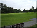
The main course.
A view from the restaurant.
Image: © stan lewis
Taken: 31 Jul 2008
0.14 miles
7
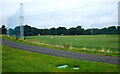
The driving range
High fencing to protect pedestrians.
Image: © stan lewis
Taken: 31 Jul 2008
0.15 miles
8
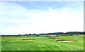
Start of the nine hole course.
Heading South-southwest.
Image: © stan lewis
Taken: 13 Aug 2008
0.16 miles
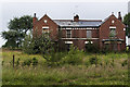
9
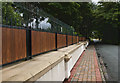
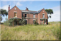
The road passes the heavily fortified Formby Hall Farm
The signs warn of guard dogs
Image: © Ian Greig
Taken: 15 Jul 2016
0.16 miles
10
Third hole.
I noticed that golf balls don't float.
Image: © stan lewis
Taken: 31 Jul 2008
0.17 miles