IMAGES TAKEN NEAR TO
Paul Street, LIVERPOOL, L3 6DX
Introduction
This page details the photographs taken nearby to Paul Street, L3 6DX by members of the Geograph project.
The Geograph project started in 2005 with the aim of publishing, organising and preserving representative images for every square kilometre of Great Britain, Ireland and the Isle of Man.

There are currently over 7.5m images from over14,400 individuals and you can help contribute to the project by visiting https://www.geograph.org.uk
Image Map (Loading...)


Getting Data...Please wait
Leaflet Map data © OpenStreetMap
Images are licensed for reuse under creativecommons.org/licenses/by-sa/2.0
Notes
- Clicking on the map will re-center to the selected point.
- The higher the marker number, the further away the image location is from the centre of the postcode.
Image Listing (23 Images Found)
Images are licensed for reuse under creativecommons.org/licenses/by-sa/2.0
Image
Details
Distance
1
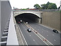
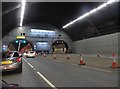
Liverpool: Kingsway Tunnel portal & A59 road
This is the Liverpool end of the Kingsway tunnel leading to Wallasey. It was built between 1966 and 1971 and opened by Queen Elizabeth II on 24 June of that year. The road is the A59 that leads to the M53 Motorway.
Image: © Nigel Cox
Taken: 16 Jun 2007
0.02 miles
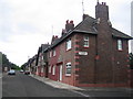
3
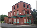
Liverpool: The former Non Pareil public house, L3
The community that this former Bass house served, at the junction of Marshall Place with Summer Seat, has just disappeared, either by wartime bomb damage, or by slum clearance, or by the works for the approach road to the Kingsway Tunnel in the early 1970s. Whatever, it found itself at the far end of a no through road and now surrounded on two sides by scrub vegetation, and presumably was just not viable. It is currently up for auction, with planning permission to convert it into a residential block, through Sutton Kersh with guide price of £190,000.
Image: © Nigel Cox
Taken: 16 Jun 2007
0.09 miles
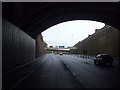
4
Entering the Kingsway Tunnel
The second Mersey Tunnel, built because the Queensway Tunnel could no longer cope with the volume of traffic. It connects Liverpool to Wallasey.
Image: © Eirian Evans
Taken: 23 May 2016
0.10 miles
5
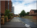
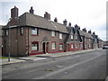
Liverpool: Summer Seat, Vauxhall, L3
This intriguingly named street has some fine Edwardian terraced cottages dating from around 1911. There is a photo of the street taken just after the houses were built, but taken of the other end, here http://www.mersey-gateway.org/pastliverpool/housing/terrace/terrace.htm
Image: © Nigel Cox
Taken: 16 Jun 2007
0.11 miles
8
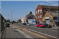
Liverpool: Bevington Street, Vauxhall, L3
This is a terrace of classic Edwardian houses built in 1911, only spoilt by some unsympathetic replacement doors and windows. However the broad street and open aspect conceal the fact that the terrace in the parallel street to the rear of these properties, Summer Seat, is very close, and just visible at the far left of the photo.
Image: © Nigel Cox
Taken: 16 Jun 2007
0.16 miles
9
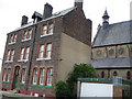
Our Lady of Reconciliation Priest's House & Church
The parish of Our Lady of Reconciliation de la Salette was originally established in 1854. The first church was a converted warehouse in Blackstock Street. The parish was established to cater for the large numbers of Irish people coming to Liverpool at the time of the famine in 1847 who settled in this area.
Image: © Sue Adair
Taken: 24 May 2008
0.18 miles