IMAGES TAKEN NEAR TO
Lathom Road, LIVERPOOL, L36 9XU
Introduction
This page details the photographs taken nearby to Lathom Road, L36 9XU by members of the Geograph project.
The Geograph project started in 2005 with the aim of publishing, organising and preserving representative images for every square kilometre of Great Britain, Ireland and the Isle of Man.

There are currently over 7.5m images from over14,400 individuals and you can help contribute to the project by visiting https://www.geograph.org.uk
Image Map
Images are licensed for reuse under creativecommons.org/licenses/by-sa/2.0
Notes
- Clicking on the map will re-center to the selected point.
- The higher the marker number, the further away the image location is from the centre of the postcode.
Image Listing (56 Images Found)
Images are licensed for reuse under creativecommons.org/licenses/by-sa/2.0
Image
Details
Distance
2
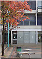
Autumn colour in Sherborne Square
Part of Huyton's shopping centre.
Image: © Alan Murray-Rust
Taken: 5 Oct 2008
0.06 miles
3
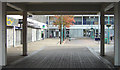
Sherborne Square
Part of the Huyton Shopping Centre. Not exactly a hive activity at 10.30 am on a Sunday morning.
Image: © Alan Murray-Rust
Taken: 5 Oct 2008
0.06 miles
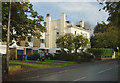
4
Park Hall
Disused community hall on Huyton Hey Road.
Image: © Alan Murray-Rust
Taken: 5 Oct 2008
0.07 miles
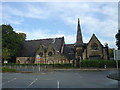
5
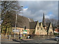
Park Hall
The original Huyton Chapel was in Pinnington Place, built to seat 220 to 230 people and opened in June 1836. In 1856 it was succeeded by this much larger church in Hey Road, built of stone from the nearby Huyton Quarry. After the coming of the railway and building of grand villas in the area, the growing congregation transferred to the new, larger United Reformed Church. The old church, renamed Park Hall continued to be used as a day school until the early 1930's when the school moved to new, modern premises in St John's Road, it then became a community hall, hosting dances for the local people until it closed and was sold in 1986. Presently "to let".
Image: © Sue Adair
Taken: 7 Feb 2009
0.07 miles
6
New and old
Contrasting housing styles on Victoria Road.
Image: © Alan Murray-Rust
Taken: 5 Oct 2008
0.07 miles
7
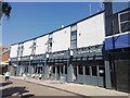
Huyton Village Revamp
Recently revamped retail properties on Derby Road, improvements included repairing and painting brickwork, replacing windows, shop fronts and signage.
Image: © Sue Adair
Taken: 3 Jul 2019
0.08 miles
8
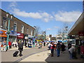
Huyton Town Centre
Still referred to as "The Village" by locals, Huyton Town centre looking north along Derby Road to St Michael's church. Just visible is the construction of the new retail development on the former Asda site which will be completed at the end of 2006.
Image: © Sue Adair
Taken: 10 Apr 2006
0.09 miles
9
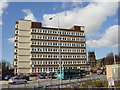
Jobcentreplus and DSS Building, Huyton
Jobcentreplus and DSS Building on Lathom Road, as seen from Asda, Huyton.
Image: © Sue Adair
Taken: 10 Apr 2006
0.09 miles
10
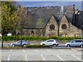
Huyton, Park Hall
Park Hall which was built in 1856 using stone from Huyton Quarry, is an attractive, neo-gothic, church building within the Huyton Conservation Area. The building was the original Huyton Congregation Church, which had become too small for the growing congregation. A new larger Congregational (now United Reformed) church was built in 1890 on Seel Road (https://www.knowsley.gov.uk/pdf/conservation_appraisal_victoria_road.pdf Conservation Area Appraisal, Knowsley Council).
The old church, renamed Park Hall continued to be used as a school until the early 1930s. When the school moved to new, modern premises in St John's Road, the building became a community hall until it closed and sold in 1986. Park Hall is a grade II listed building (English Heritage Building ID: 215264 http://www.britishlistedbuildings.co.uk/en-215264-park-hall-#.VUYgLGd0x_s British Listed Buildings). Currently (2015) boarded up and “To Let”.
Image: © David Dixon
Taken: 27 Apr 2015
0.10 miles