IMAGES TAKEN NEAR TO
Kingsway, LIVERPOOL, L36 9UF
Introduction
This page details the photographs taken nearby to Kingsway, L36 9UF by members of the Geograph project.
The Geograph project started in 2005 with the aim of publishing, organising and preserving representative images for every square kilometre of Great Britain, Ireland and the Isle of Man.

There are currently over 7.5m images from over14,400 individuals and you can help contribute to the project by visiting https://www.geograph.org.uk
Image Map
Images are licensed for reuse under creativecommons.org/licenses/by-sa/2.0
Notes
- Clicking on the map will re-center to the selected point.
- The higher the marker number, the further away the image location is from the centre of the postcode.
Image Listing (5 Images Found)
Images are licensed for reuse under creativecommons.org/licenses/by-sa/2.0
Image
Details
Distance
3
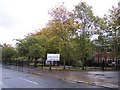
Knowsley Community College
This once was Huyton Secondary Modern,Freddy Starr's school
Image: © Raymond Knapman
Taken: 19 Oct 2010
0.15 miles
4
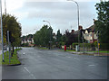
Archway Road
At the junction with Rupert Road. The name doubtless derives from the fact that it was bridged by the Liverpool and Manchester Railway, a real novelty at the time.
Image: © Alan Murray-Rust
Taken: 5 Oct 2008
0.22 miles
5
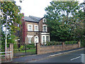
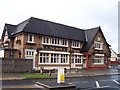
Victorian house on Archway Road
At the corner of Rupert Road.
Image: © Alan Murray-Rust
Taken: 5 Oct 2008
0.25 miles