IMAGES TAKEN NEAR TO
Huyton Lane, LIVERPOOL, L36 7XD
Introduction
This page details the photographs taken nearby to Huyton Lane, L36 7XD by members of the Geograph project.
The Geograph project started in 2005 with the aim of publishing, organising and preserving representative images for every square kilometre of Great Britain, Ireland and the Isle of Man.

There are currently over 7.5m images from over14,400 individuals and you can help contribute to the project by visiting https://www.geograph.org.uk
Image Map
Images are licensed for reuse under creativecommons.org/licenses/by-sa/2.0
Notes
- Clicking on the map will re-center to the selected point.
- The higher the marker number, the further away the image location is from the centre of the postcode.
Image Listing (27 Images Found)
Images are licensed for reuse under creativecommons.org/licenses/by-sa/2.0
Image
Details
Distance
1

ASDA, Huyton
The ASDA Wal-mart supercentre in Huyton which was built on land opposite the old ASDA supermarket. A new shopping centre has been built on the previous site.
Image: © Sue Adair
Taken: 28 Aug 2005
0.06 miles
2
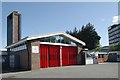
Huyton fire station
Huyton fire station, Huyton Lane, Huyton, Liverpool
Image: © Kevin Hale
Taken: 27 May 2010
0.08 miles
3
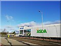
ASDA Supercentre Huyton
The ASDA supercentre on Lathom Road opened on the 28th August 2005, it was built on land opposite the old ASDA supermarket which had opened in 1977 and has been replaced by the Cavendish Walk development.
Image: © Sue Adair
Taken: 24 Dec 2020
0.10 miles
4
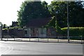
Huyton old fire station
Huyton old fire station, Huyton Lane, Huyton, Liverpool, lies opposite the current fire station, and hides all evidence of its former use
Image: © Kevin Hale
Taken: 27 May 2010
0.11 miles
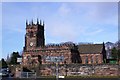
6
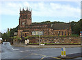
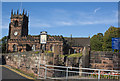
Huyton Parish Church
Dedicated to St Michael. The red sandstone is typical of large numbers of churches in south Lancashire and northern Cheshire.
Image: © Alan Murray-Rust
Taken: 5 Oct 2008
0.14 miles
7
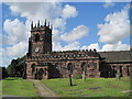
St Michael's Church, Huyton
The present St Michael's church dates from 1663 but a church has stood on this site for many centuries before. Churches like this built on rocky outcrops frequently occupy ancient religious sites predating Christianity. Huyton, like its neighbour Roby, were mentioned in the Domesday book and a Saxon stone column capital was found by the church in 1873 also a 8/9th C sandstone font.
Image: © Sue Adair
Taken: 30 Jul 2009
0.14 miles
8
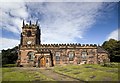
St Michael's Church, Huyton
Grade II* listed building at the centre of a small conservation area. The church is of medieval origin and most of the existing building is from the 14th to the 19th century. Although it has been altered over many centuries it retains notable features of different periods - an early Norman font found buried under the Tower in 1872, a second font of octagonal design, and a 15th century timber rood screen.
Image: © Paul Harrop
Taken: 28 Sep 2012
0.14 miles
10
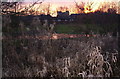
Fiery sunset, Huyton
Wetlands in Huyton where the River Alt rises.
Image: © S Parish
Taken: 18 Feb 2006
0.15 miles