IMAGES TAKEN NEAR TO
Salerno Drive, LIVERPOOL, L36 7UA
Introduction
This page details the photographs taken nearby to Salerno Drive, L36 7UA by members of the Geograph project.
The Geograph project started in 2005 with the aim of publishing, organising and preserving representative images for every square kilometre of Great Britain, Ireland and the Isle of Man.

There are currently over 7.5m images from over14,400 individuals and you can help contribute to the project by visiting https://www.geograph.org.uk
Image Map
Images are licensed for reuse under creativecommons.org/licenses/by-sa/2.0
Notes
- Clicking on the map will re-center to the selected point.
- The higher the marker number, the further away the image location is from the centre of the postcode.
Image Listing (2 Images Found)
Images are licensed for reuse under creativecommons.org/licenses/by-sa/2.0
Image
Details
Distance
1
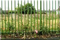
Demolished day nursery, Montgomery Road
Image: © Alex McGregor
Taken: 21 Oct 2014
0.10 miles
2
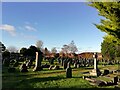
Huyton Parish Church Cemetery
Huyton Parish Church Cemetery opened in the 1880's as the small churchyard of St Michael's parish church was full. Here is the final resting place of Stuart Sutcliffe, the former Beatle who died in Hamburg of a brain haemorrhage on April 10th 1962 at the age of 21. The group's manager, Brian Epstein, arranged the repatriation of his body to Huyton where he had been brought up.
Image: © Sue Adair
Taken: 24 Dec 2020
0.24 miles