IMAGES TAKEN NEAR TO
Stretton Way, LIVERPOOL, L36 6JF
Introduction
This page details the photographs taken nearby to Stretton Way, L36 6JF by members of the Geograph project.
The Geograph project started in 2005 with the aim of publishing, organising and preserving representative images for every square kilometre of Great Britain, Ireland and the Isle of Man.

There are currently over 7.5m images from over14,400 individuals and you can help contribute to the project by visiting https://www.geograph.org.uk
Image Map
Images are licensed for reuse under creativecommons.org/licenses/by-sa/2.0
Notes
- Clicking on the map will re-center to the selected point.
- The higher the marker number, the further away the image location is from the centre of the postcode.
Image Listing (6 Images Found)
Images are licensed for reuse under creativecommons.org/licenses/by-sa/2.0
Image
Details
Distance
3
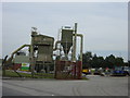
Wilson Road Industrial Estate
Tarmac plant on Wilson Road Industrial Estate Huyton.
Image: © Sue Adair
Taken: 18 Aug 2005
0.13 miles
4
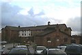
The Village
On the site of the former St. Nicholas Vicarage
Image: © David Long
Taken: 24 Nov 2005
0.22 miles
5
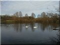
Tushingham's Pond in Stadt Moers Park
Tushingham's Metallic Brickworks stood on this site from 1898 until 1970 manufacturing bricks from a mixture of local clay and shale. The brickworks was demolished in the late 1970’s with the chimney being the last landmark to stand. Where the pond now sits is where clay for bricks was extracted.
Image: © Sue Adair
Taken: 1 Feb 2021
0.23 miles
6
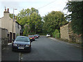
Windy Arbor Brow
A quiet cul-de-sac which was former the main road up through Whiston from Cronton Road. This was cut through and realigned when the M62 was constructed.
Image: © Alan Murray-Rust
Taken: 3 Oct 2008
0.25 miles