IMAGES TAKEN NEAR TO
Derby Street, LIVERPOOL, L36 6BR
Introduction
This page details the photographs taken nearby to Derby Street, L36 6BR by members of the Geograph project.
The Geograph project started in 2005 with the aim of publishing, organising and preserving representative images for every square kilometre of Great Britain, Ireland and the Isle of Man.

There are currently over 7.5m images from over14,400 individuals and you can help contribute to the project by visiting https://www.geograph.org.uk
Image Map
Images are licensed for reuse under creativecommons.org/licenses/by-sa/2.0
Notes
- Clicking on the map will re-center to the selected point.
- The higher the marker number, the further away the image location is from the centre of the postcode.
Image Listing (14 Images Found)
Images are licensed for reuse under creativecommons.org/licenses/by-sa/2.0
Image
Details
Distance
1
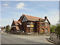
St Gabriel's Community Centre, Huyton
St Gabriel's Community Centre on Hall Lane, Huyton.
Image: © Sue Adair
Taken: 3 May 2006
0.06 miles
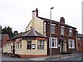
2
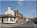
Hall Lane, Huyton Quarry
Hall Lane, Huyton Quarry and the Seel Arms public house named after the Molyneux-Seel family who owned the moated manor of Huyton Hey which stood nearby.
Image: © Sue Adair
Taken: 3 May 2006
0.06 miles
3
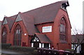
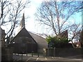
St Gabriel, Huyton Quarry
1894. Architect G Bradbury.
Image: © S Parish
Taken: 5 Apr 2007
0.08 miles
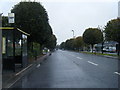
4
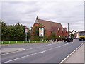
St Gabriel's in Huyton Quarry
Cronton Colliery railway once crossed the road on a level crossing at this site
Image: © Raymond Knapman
Taken: 26 Aug 2010
0.09 miles
9
St Agnes' RC Church
St Agnes' RC Church in Huyton Hey Road was built in 1965 to replace the smaller St Agnes' Chapel of the previous century.
Image: © Sue Adair
Taken: 7 Feb 2009
0.21 miles
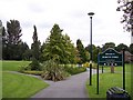
10
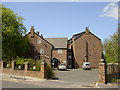
Huyton Hey Manor Farm
Together with the land given by Lady Carr-Saunders (formerly Molyneux-Seel) to create Sawpit Park, this formed a portion of the manor of Huyton Hey which the Molyneux-Seel family owned for generations, the moated hall was situated opposite on Hall Lane. Huyton Hey Manor farm on Huyton Hey Road, is the Huyton's oldest surviving secular building. Originally with a datestone of 1670, it was recently renovated and enlarged and is now a residential home.
Image: © Sue Adair
Taken: 3 May 2006
0.22 miles