IMAGES TAKEN NEAR TO
Cedar Crescent, LIVERPOOL, L36 5UP
Introduction
This page details the photographs taken nearby to Cedar Crescent, L36 5UP by members of the Geograph project.
The Geograph project started in 2005 with the aim of publishing, organising and preserving representative images for every square kilometre of Great Britain, Ireland and the Isle of Man.

There are currently over 7.5m images from over14,400 individuals and you can help contribute to the project by visiting https://www.geograph.org.uk
Image Map
Images are licensed for reuse under creativecommons.org/licenses/by-sa/2.0
Notes
- Clicking on the map will re-center to the selected point.
- The higher the marker number, the further away the image location is from the centre of the postcode.
Image Listing (6 Images Found)
Images are licensed for reuse under creativecommons.org/licenses/by-sa/2.0
Image
Details
Distance
2
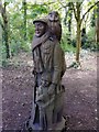
Carved Tree Trunk Ten Acre Pits
Ten Acre Pits is a local community woodland on the Paramount estate, the name comes from the former marl pits which occupied the site in the 18th century. Popular with dog walkers and local children the paths meander through the small woodland and have wood carvings such as this on display and is a haven for wildllife.
Image: © Sue Adair
Taken: 20 Apr 2020
0.12 miles
3
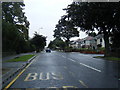
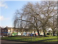
The Park
Looking towards Tarbock Road from Rydal Road.
Image: © Alan Murray-Rust
Taken: 5 Oct 2008
0.15 miles
5
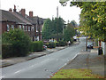
Roundabout and shops at Tarbock Road
Junction of Tarbock Road with Roby Road, Archway Road and Blacklow Brow.
Image: © Sue Adair
Taken: 26 Dec 2016
0.23 miles
6
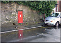
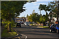
Postbox, Blacklow Brow
Outside Huyton Station. This is an unusually large box for a wall box, so I included the car to give a sense of scale.
Image: © Alan Murray-Rust
Taken: 5 Oct 2008
0.25 miles