IMAGES TAKEN NEAR TO
Tarbock Road, LIVERPOOL, L36 5TQ
Introduction
This page details the photographs taken nearby to Tarbock Road, L36 5TQ by members of the Geograph project.
The Geograph project started in 2005 with the aim of publishing, organising and preserving representative images for every square kilometre of Great Britain, Ireland and the Isle of Man.

There are currently over 7.5m images from over14,400 individuals and you can help contribute to the project by visiting https://www.geograph.org.uk
Image Map
Images are licensed for reuse under creativecommons.org/licenses/by-sa/2.0
Notes
- Clicking on the map will re-center to the selected point.
- The higher the marker number, the further away the image location is from the centre of the postcode.
Image Listing (16 Images Found)
Images are licensed for reuse under creativecommons.org/licenses/by-sa/2.0
Image
Details
Distance
2
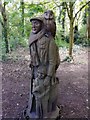
Carved Tree Trunk Ten Acre Pits
Ten Acre Pits is a local community woodland on the Paramount estate, the name comes from the former marl pits which occupied the site in the 18th century. Popular with dog walkers and local children the paths meander through the small woodland and have wood carvings such as this on display and is a haven for wildllife.
Image: © Sue Adair
Taken: 20 Apr 2020
0.14 miles
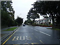
3
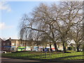
The Park
Looking towards Tarbock Road from Rydal Road.
Image: © Alan Murray-Rust
Taken: 5 Oct 2008
0.15 miles
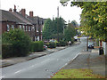
5
Roundabout and shops at Tarbock Road
Junction of Tarbock Road with Roby Road, Archway Road and Blacklow Brow.
Image: © Sue Adair
Taken: 26 Dec 2016
0.21 miles
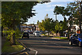
6
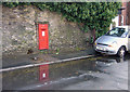
Postbox, Blacklow Brow
Outside Huyton Station. This is an unusually large box for a wall box, so I included the car to give a sense of scale.
Image: © Alan Murray-Rust
Taken: 5 Oct 2008
0.23 miles
7
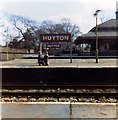
Huyton Station, about 1970
View looking west to Liverpool. DMU at platform 2 on the Manchester line.
Image: © John Martin
Taken: Unknown
0.23 miles
8
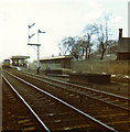
Huyton Station about 1970 - platform ends
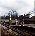
View looking south across the platform ends at the east end of Huyton Station. Line visible (platform 3) out of use, nearest line (platform 4) taken up. These were the two slow lines, which veered off to Wigan a few yards to the east. Wigan trains now cross to the other two platforms. Nice signs! Please contact if you can date the shot by the closure of the two slow lines.
Image: © John Martin
Taken: Unknown
0.23 miles
9
Huyton Station about 1970 - subway from middle platform
Two youngsters dangle their legs precariously, though the line was by now closed into platform 3. The subway was a magical spooky place with echoes and shadows, linking Huyton Village (left) via the station to Blacklow Brow. Originally, when the station was called Huyton Gate, there was a level crossing here instead. Another subway linked the four platforms, and this survives in part.
Image: © John Martin
Taken: Unknown
0.23 miles
10
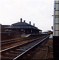
Huyton Station about 1970 - platform 1
The attractive and historic main station buildings on platform 1 at Huyton (on the fast line from Manchester Victoria, earlier Exchange) A DMU stands at platform 2.
Image: © John Martin
Taken: Unknown
0.23 miles