IMAGES TAKEN NEAR TO
St. Marys Road, LIVERPOOL, L36 5SS
Introduction
This page details the photographs taken nearby to St. Marys Road, L36 5SS by members of the Geograph project.
The Geograph project started in 2005 with the aim of publishing, organising and preserving representative images for every square kilometre of Great Britain, Ireland and the Isle of Man.

There are currently over 7.5m images from over14,400 individuals and you can help contribute to the project by visiting https://www.geograph.org.uk
Image Map
Images are licensed for reuse under creativecommons.org/licenses/by-sa/2.0
Notes
- Clicking on the map will re-center to the selected point.
- The higher the marker number, the further away the image location is from the centre of the postcode.
Image Listing (43 Images Found)
Images are licensed for reuse under creativecommons.org/licenses/by-sa/2.0
Image
Details
Distance
1
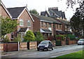
St Agnes Road
Alongside McGoldrick Park. Modern housing has largely replace the Victorian villas that once would have graced this road, as witnessed by the old brick walls. In practice, the older houses almost certainly all faced onto the adjacent St Mary's Road, as all the remaining ones do; probably St Agnes Road served simply as carriage access.
Image: © Alan Murray-Rust
Taken: 5 Oct 2008
0.02 miles
2
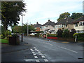
St Mary's Road
The western section, in the Huyton Park district around McGoldrick Park.
Image: © Alan Murray-Rust
Taken: 5 Oct 2008
0.03 miles
3
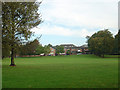
McGoldrick Park
Looking north to the houses on St Agnes Road.
Image: © Alan Murray-Rust
Taken: 5 Oct 2008
0.04 miles
4
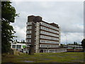
Job Centre/Social Security Building
Taken from St Michael's churchyard, one of Huyton's landmark twin towers is the Job Centre and Social Security building. Situated on the corner of Lathom Road and Archway Road next to the original ASDA site now being redeveloped, you can see the new ASDA/Wallmart superstore in the background.
Image: © Sue Adair
Taken: 13 Aug 2005
0.04 miles
5
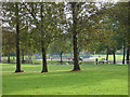
McGoldrick Park from The Park
The more formal recreation facilities are on the far side of Rydal Road which bisects the Park.
Image: © Alan Murray-Rust
Taken: 5 Oct 2008
0.08 miles
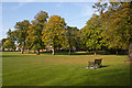
7
October morning sun in mcGoldrick Park
Image: © Alan Murray-Rust
Taken: 5 Oct 2008
0.08 miles
8
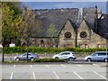
Huyton, Park Hall
Park Hall which was built in 1856 using stone from Huyton Quarry, is an attractive, neo-gothic, church building within the Huyton Conservation Area. The building was the original Huyton Congregation Church, which had become too small for the growing congregation. A new larger Congregational (now United Reformed) church was built in 1890 on Seel Road (https://www.knowsley.gov.uk/pdf/conservation_appraisal_victoria_road.pdf Conservation Area Appraisal, Knowsley Council).
The old church, renamed Park Hall continued to be used as a school until the early 1930s. When the school moved to new, modern premises in St John's Road, the building became a community hall until it closed and sold in 1986. Park Hall is a grade II listed building (English Heritage Building ID: 215264 http://www.britishlistedbuildings.co.uk/en-215264-park-hall-#.VUYgLGd0x_s British Listed Buildings). Currently (2015) boarded up and “To Let”.
Image: © David Dixon
Taken: 27 Apr 2015
0.08 miles
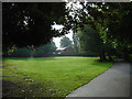
9
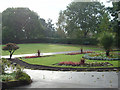
Bowling green
With ornamental flower beds, in McGoldrick Park
Image: © Alan Murray-Rust
Taken: 5 Oct 2008
0.09 miles
10
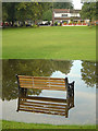
Dry weather seating only!
Apparently this part of McGoldrick Park regularly gets waterlogged after heavy rain - if so one has to ask why it was chosen for the benches.
Image: © Alan Murray-Rust
Taken: 5 Oct 2008
0.10 miles