IMAGES TAKEN NEAR TO
Jeffereys Drive, LIVERPOOL, L36 4NT
Introduction
This page details the photographs taken nearby to Jeffereys Drive, L36 4NT by members of the Geograph project.
The Geograph project started in 2005 with the aim of publishing, organising and preserving representative images for every square kilometre of Great Britain, Ireland and the Isle of Man.

There are currently over 7.5m images from over14,400 individuals and you can help contribute to the project by visiting https://www.geograph.org.uk
Image Map
Images are licensed for reuse under creativecommons.org/licenses/by-sa/2.0
Notes
- Clicking on the map will re-center to the selected point.
- The higher the marker number, the further away the image location is from the centre of the postcode.
Image Listing (13 Images Found)
Images are licensed for reuse under creativecommons.org/licenses/by-sa/2.0
Image
Details
Distance
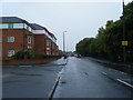
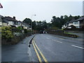
1
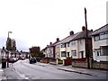
Windsor Road ,Roby
Beechburn Crescent joins on the right
Image: © Raymond Knapman
Taken: 19 Oct 2010
0.13 miles
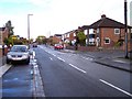
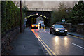
4
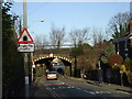
Pilch Lane East
View towards narrow bridge under the original Liverpool to Manchester Railway line
Image: © Colin Pyle
Taken: 13 Sep 2010
0.15 miles
5
Pilch Lane East burrows under the Liverpool Manchester railway
Very narrow and low tunnel restricts allowable vehicles
Image: © Raymond Knapman
Taken: 19 Oct 2010
0.15 miles
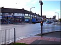
6
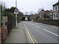
Roby: Pilch Lane East
The distant narrow bridge, which carries the railway between Roby and Broad Green stations over Pilch Lane East, is a Grade II listed building.
Image: © Nigel Cox
Taken: 19 Feb 2007
0.18 miles
8
Railway bridge, Pilch Lane East, Liverpool
Image: © John Lord
Taken: 26 Dec 2008
0.21 miles
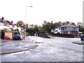
9
Ashbourne Crescent
One of several crescents in this area
Image: © Raymond Knapman
Taken: 19 Oct 2010
0.21 miles