IMAGES TAKEN NEAR TO
Easton Road, LIVERPOOL, L36 4AL
Introduction
This page details the photographs taken nearby to Easton Road, L36 4AL by members of the Geograph project.
The Geograph project started in 2005 with the aim of publishing, organising and preserving representative images for every square kilometre of Great Britain, Ireland and the Isle of Man.

There are currently over 7.5m images from over14,400 individuals and you can help contribute to the project by visiting https://www.geograph.org.uk
Image Map
Images are licensed for reuse under creativecommons.org/licenses/by-sa/2.0
Notes
- Clicking on the map will re-center to the selected point.
- The higher the marker number, the further away the image location is from the centre of the postcode.
Image Listing (7 Images Found)
Images are licensed for reuse under creativecommons.org/licenses/by-sa/2.0
Image
Details
Distance
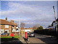
2
Shops at the corner of Dinas Lane and Page Moss Lane, Huyton-with-Roby
Image: © John Lord
Taken: 27 Dec 2011
0.14 miles
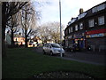
3
Junction of Page Moss Lane and Dinas Lane, Huyton-with-Roby
Image: © John Lord
Taken: 27 Dec 2011
0.16 miles
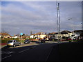
5

Bowring Comprehensive, Western Avenue, Huyton-with-Roby
Knowsley Bowring Comprehensive was situated on Western Avenue, Huyton-with-Roby. It closed on 31/8/2009 as a result of amalgamation and was demolished in 2010.
Image: © Sue Adair
Taken: 3 Mar 2006
0.17 miles
6
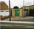
Electricity sub station, Beechburn Crescent, Page Moss
Image: © Alex McGregor
Taken: 17 May 2012
0.23 miles
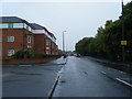
7
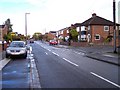
Windsor Road ,Roby
Beechburn Crescent joins on the right
Image: © Raymond Knapman
Taken: 19 Oct 2010
0.24 miles