IMAGES TAKEN NEAR TO
Knowsley Heights, LIVERPOOL, L36 3SS
Introduction
This page details the photographs taken nearby to Knowsley Heights, L36 3SS by members of the Geograph project.
The Geograph project started in 2005 with the aim of publishing, organising and preserving representative images for every square kilometre of Great Britain, Ireland and the Isle of Man.

There are currently over 7.5m images from over14,400 individuals and you can help contribute to the project by visiting https://www.geograph.org.uk
Image Map
Images are licensed for reuse under creativecommons.org/licenses/by-sa/2.0
Notes
- Clicking on the map will re-center to the selected point.
- The higher the marker number, the further away the image location is from the centre of the postcode.
Image Listing (8 Images Found)
Images are licensed for reuse under creativecommons.org/licenses/by-sa/2.0
Image
Details
Distance
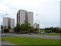
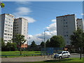
2
Knowsley Heights, Huyton
Knowsley Heights at the junction of Primrose Lane with Liverpool Road (A57), Huyton.
Image: © Sue Adair
Taken: 10 Apr 2006
0.02 miles
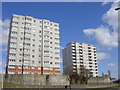
3
Knowsley Heights
Knowsley Heights as seen from Nyland Road.
Image: © Sue Adair
Taken: 7 Aug 2012
0.03 miles
4
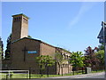
Church of St George, Huyton
Church of St George at the junction of Primrose Drive and Hillside Road, Huyton
Image: © Sue Adair
Taken: 2 Jun 2006
0.21 miles
5
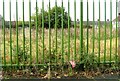
Demolished day nursery, Montgomery Road
Image: © Alex McGregor
Taken: 21 Oct 2014
0.21 miles
6
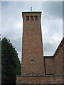
Tower of St George's Church, Huyton
Church consecrated 14 December 1958; architect Quiggin and Gee.
Image: © S Parish
Taken: 11 Oct 2008
0.23 miles
7
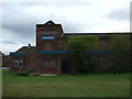
St George's Church Hall
A building that may be demolished in 2014
Image: © S Parish
Taken: 13 Oct 2008
0.24 miles