IMAGES TAKEN NEAR TO
Greenway Close, LIVERPOOL, L36 2ND
Introduction
This page details the photographs taken nearby to Greenway Close, L36 2ND by members of the Geograph project.
The Geograph project started in 2005 with the aim of publishing, organising and preserving representative images for every square kilometre of Great Britain, Ireland and the Isle of Man.

There are currently over 7.5m images from over14,400 individuals and you can help contribute to the project by visiting https://www.geograph.org.uk
Image Map
Images are licensed for reuse under creativecommons.org/licenses/by-sa/2.0
Notes
- Clicking on the map will re-center to the selected point.
- The higher the marker number, the further away the image location is from the centre of the postcode.
Image Listing (8 Images Found)
Images are licensed for reuse under creativecommons.org/licenses/by-sa/2.0
Image
Details
Distance
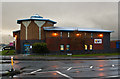
3
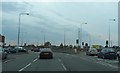
PDSA Animal Hospital
This much needed PDSA veterinary hospital was built a few years ago, this area at the junction of Woollfall Heath Avenue, Stockbridge Lane and Liverpool Road had always been known as Horn Smithies but no one seems to know why! It is now more often referred to as Page Moss, at least that's what the buses say on the front
Image: © Sue Adair
Taken: 14 Aug 2005
0.20 miles
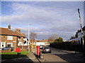
5
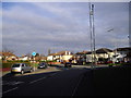
Junction of Page Moss Lane and Dinas Lane, Huyton-with-Roby
Image: © John Lord
Taken: 27 Dec 2011
0.21 miles
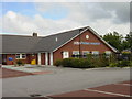
6
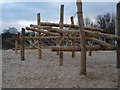
Jubilee Park Play Area
New play area adorns Jubilee Park, sand covered floors to prevent nasty falls.
Image: © Andrea Dowling
Taken: 6 Mar 2010
0.21 miles
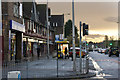
7
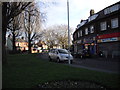
Shops at the corner of Dinas Lane and Page Moss Lane, Huyton-with-Roby
Image: © John Lord
Taken: 27 Dec 2011
0.22 miles