IMAGES TAKEN NEAR TO
Cotsford Way, LIVERPOOL, L36 2LH
Introduction
This page details the photographs taken nearby to Cotsford Way, L36 2LH by members of the Geograph project.
The Geograph project started in 2005 with the aim of publishing, organising and preserving representative images for every square kilometre of Great Britain, Ireland and the Isle of Man.

There are currently over 7.5m images from over14,400 individuals and you can help contribute to the project by visiting https://www.geograph.org.uk
Image Map
Images are licensed for reuse under creativecommons.org/licenses/by-sa/2.0
Notes
- Clicking on the map will re-center to the selected point.
- The higher the marker number, the further away the image location is from the centre of the postcode.
Image Listing (7 Images Found)
Images are licensed for reuse under creativecommons.org/licenses/by-sa/2.0
Image
Details
Distance
2
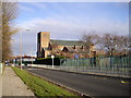
St Aloysius R.C.Church, Twig Lane, Huyton-with-Roby
Image: © John Lord
Taken: 27 Dec 2011
0.12 miles
3
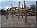
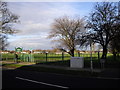
Jubilee Park Play Area
New play area adorns Jubilee Park, sand covered floors to prevent nasty falls.
Image: © Andrea Dowling
Taken: 6 Mar 2010
0.13 miles
4
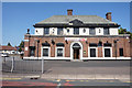
The Oak Tree Public House
On Liverpool Road, Huyton.
Image: © Ian S
Taken: 23 Jul 2019
0.16 miles
5
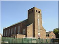
St Aloysius Church, Twig Lane, Huyton
St Aloysius church is located in Twig Lane Huyton. It has a popular social club and a primary school adjacent to the church.
Image: © Sue Adair
Taken: 2 Jun 2006
0.17 miles