IMAGES TAKEN NEAR TO
Pembroke Place, LIVERPOOL, L3 5PS
Introduction
This page details the photographs taken nearby to Pembroke Place, L3 5PS by members of the Geograph project.
The Geograph project started in 2005 with the aim of publishing, organising and preserving representative images for every square kilometre of Great Britain, Ireland and the Isle of Man.

There are currently over 7.5m images from over14,400 individuals and you can help contribute to the project by visiting https://www.geograph.org.uk
Image Map
Images are licensed for reuse under creativecommons.org/licenses/by-sa/2.0
Notes
- Clicking on the map will re-center to the selected point.
- The higher the marker number, the further away the image location is from the centre of the postcode.
Image Listing (77 Images Found)
Images are licensed for reuse under creativecommons.org/licenses/by-sa/2.0
Image
Details
Distance
1
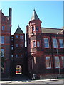
Royal Infirmary, Liverpool
Part of the buildings (architect Alfred Waterhouse) dating from the late 1880s. After being replaced by the modern Royal Liverpool University Hospital in the 1970s, the site was eventually taken over by Liverpool University in the 90s. Seen here from the junction of Daulby St with Pembroke Place.
Image: © Derek Harper
Taken: 17 Jul 2006
0.06 miles
2

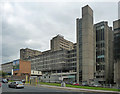
Royal Liverpool University Hospital, Prescot Street, Liverpool (1)
A mighty palace of concrete. Planned from 1963-65 and opened in 1978. The architects were Holford Associates. This elevation to West Derby Street is a massive regular grid, behind which are the wards. Contrary to appearances the concrete members do not touch the windows but project. On the left is one of two rather sculptural ventilation ducts.
The hospital has more than 700 beds, the largest in the area by some distance, and its Emergency Department is supposedly the largest in the country. Unfathomably, not everyone appreciates concrete and a plan to demolish the current buildings is making headway.
For the Prescot Street elevation: Image
Image: © Stephen Richards
Taken: 26 Jul 2011
0.06 miles
3

Sherrington Buildings, Ashton Street, Liverpool
Built for the University of Liverpool, 1951-57, by Weightman & Bullen.
It houses the Faculty of Medicine.
Image: © Stephen Richards
Taken: 26 Jul 2011
0.07 miles
4
Buildings at University of Liverpool
In the foreground, across Ashton Street, is the northern part of the building shown in Image On the right is Cedar House, University of Liverpool's School of Medicine, which opened the November after this photo was taken, and is based in the former Liverpool Royal Infirmary Nurses Home.
Image: © Derek Harper
Taken: 17 Jul 2006
0.07 miles
5
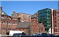
Daulby Street, Liverpool
Showing the Spiritualist Church and the Roy Castle International Centre for Lung Cancer Research; junction with London Road in the background.
Image: © Derek Harper
Taken: 17 Jul 2006
0.07 miles

8

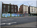
Junction of London Road, Moss Street and several others, Liverpool
Visible straight ahead, on the corner of Moss Street (left) and Prescot Street (right), is the former Bank of Liverpool. Towards the left is the former Prince of Wales public house; both buildings are grade-II listed. Adjoining the Prince of Wales public house, on the extreme left, is Albert Court (formerly Opal Court), a student accommodation building completed in 2006. It adjoins the Prince of Wales on its opposite side too, and incorporates part of the interior for its uses. Most of the original building, however, is disused and this is very much evident from outside. The fourth road is Daulby Street.
Image: © Oliver Mills
Taken: 18 Sep 2023
0.10 miles
9
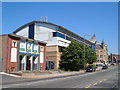
Royal Liverpool University Hospital, Prescot Street, Liverpool (2)
A mighty palace of concrete. Planned from 1963-65 and opened in 1978. The architects were Holford Associates. Behind the long grid are clinical departments, the higher projecting sections behind house teaching blocks. Nearer the camera is a stair tower.
The hospital has more than 700 beds, the largest in the area by some distance, and its Emergency Department is supposedly the largest in the country. Unfathomably, not everyone appreciates concrete and a plan to demolish the current buildings is making headway.
The other side: Image
Image: © Stephen Richards
Taken: 27 Jul 2011
0.10 miles
10
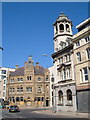
Junction of Moss Street and Prescot Street, Liverpool
On the right is the baroque-influenced Martins Bank, 1905. The gothic building opposite, between London Road and Moss Street, is the former Prince of Wales pub (closed in 1999), now converted into student accommodation behind the facade (thanks to Sue Adair for this information).
Image: © Derek Harper
Taken: 17 Jul 2006
0.10 miles