IMAGES TAKEN NEAR TO
Severn Road, PRESCOT, L35 9LH
Introduction
This page details the photographs taken nearby to Severn Road, L35 9LH by members of the Geograph project.
The Geograph project started in 2005 with the aim of publishing, organising and preserving representative images for every square kilometre of Great Britain, Ireland and the Isle of Man.

There are currently over 7.5m images from over14,400 individuals and you can help contribute to the project by visiting https://www.geograph.org.uk
Image Map
Images are licensed for reuse under creativecommons.org/licenses/by-sa/2.0
Notes
- Clicking on the map will re-center to the selected point.
- The higher the marker number, the further away the image location is from the centre of the postcode.
Image Listing (13 Images Found)
Images are licensed for reuse under creativecommons.org/licenses/by-sa/2.0
Image
Details
Distance
4
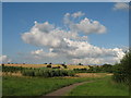
Stoney Lane crosses the Liverpool Manchester railway
Image: © Raymond Knapman
Taken: 31 Aug 2010
0.17 miles
5
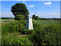
Field side path at Rainhill Triangulation Pillar
Looking north-eastward.
Image: © Peter Wood
Taken: 11 Jul 2015
0.17 miles
6
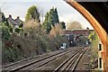
Old Lane road bridge, Rainhill railway station
Viewed from the western end of the Manchester-bound platform, from beside the A57 Warrington Road bridge, looking in the direction of Liverpool.
Image: © El Pollock
Taken: 17 Jan 2014
0.18 miles
7
Ordnance Survey Trig Pillar on Blundell's Hill, Whiston
Image: © Gary Rogers
Taken: 22 Jun 2019
0.18 miles
8
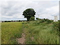
Blundell's Hill
Looking towards Blundell's Hill from near Cumber Lane access gate, a local green space popular with dog walkers and joggers. Note the lone pine tree at the highest point, it is actually a mobile phone mast.
Image: © Sue Adair
Taken: 15 Jul 2009
0.18 miles
9
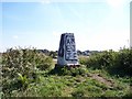
The graffiti daubed trig point on Blundell's Hill
Image: © Raymond Knapman
Taken: 31 Aug 2010
0.18 miles
10
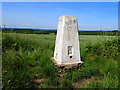
Ordnance Survey Trig Pillar on Blundell's Hill, Whiston
Image: © Gary Rogers
Taken: 22 Jun 2019
0.18 miles