IMAGES TAKEN NEAR TO
Warrington Road, PRESCOT, L35 6PB
Introduction
This page details the photographs taken nearby to Warrington Road, L35 6PB by members of the Geograph project.
The Geograph project started in 2005 with the aim of publishing, organising and preserving representative images for every square kilometre of Great Britain, Ireland and the Isle of Man.

There are currently over 7.5m images from over14,400 individuals and you can help contribute to the project by visiting https://www.geograph.org.uk
Image Map
Images are licensed for reuse under creativecommons.org/licenses/by-sa/2.0
Notes
- Clicking on the map will re-center to the selected point.
- The higher the marker number, the further away the image location is from the centre of the postcode.
Image Listing (42 Images Found)
Images are licensed for reuse under creativecommons.org/licenses/by-sa/2.0
Image
Details
Distance
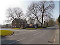
3
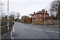
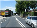
Mill Lane, Rainhill
One of the older roads in this area.
Image: © Bill Boaden
Taken: 20 Feb 2015
0.04 miles
4
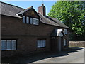
Old Smithy at Rainhill Stoops
The old blacksmith's cottage at Rainhill Stoops on Warrington Road which was an important turnpike road linking Liverpool with Warrington, Manchester and the rest of the country.
Image: © Sue Adair
Taken: 7 May 2017
0.04 miles
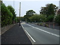
7
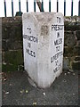
Old Milestone by the A57, Warrington Road, Rainhill Parish
Carved stone post by the A57, in parish of RAINHILL (ST HELENS District), Warrington Road; 50m West of junction with School Lane, in front of school, on East side of road. Prescot stone, erected by the Liverpool, Prescot, Ashton & Warrington turnpike trust in the 19th century.
Inscription reads:-
: TO / WARRINGTON / VII / MILES : : TO PRESCOT / III / MILES / TO / LIVERPOOL / XI / MILES :
Merseyside HER listed. https://www.heritagegateway.org.uk/Gateway/Results_Single.aspx?uid=3308408&resourceID=1970
Milestone Society National ID: LA_WALV07.
Image: © M Faherty
Taken: 24 Aug 2008
0.08 miles
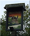
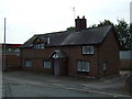
8
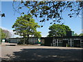
Manor Farm, Rainhill Stoops
This impressive red-sandstone building, set back from Mill Lane, is a pub/restaurant.
Image: © David Dixon
Taken: 5 Mar 2013
0.09 miles
9
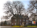
Manor Farm
This impressive red-sandstone building, set back from Mill Lane, is a pub/restaurant.
Image: © David Dixon
Taken: 5 Mar 2013
0.10 miles