IMAGES TAKEN NEAR TO
Molyneux Close, PRESCOT, L35 5DZ
Introduction
This page details the photographs taken nearby to Molyneux Close, L35 5DZ by members of the Geograph project.
The Geograph project started in 2005 with the aim of publishing, organising and preserving representative images for every square kilometre of Great Britain, Ireland and the Isle of Man.

There are currently over 7.5m images from over14,400 individuals and you can help contribute to the project by visiting https://www.geograph.org.uk
Image Map
Images are licensed for reuse under creativecommons.org/licenses/by-sa/2.0
Notes
- Clicking on the map will re-center to the selected point.
- The higher the marker number, the further away the image location is from the centre of the postcode.
Image Listing (6 Images Found)
Images are licensed for reuse under creativecommons.org/licenses/by-sa/2.0
Image
Details
Distance
1
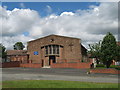
St Paul's Church, Prescot
Built in 1956, serving the parish of Prescot and Whiston.
Image: © Sue Adair
Taken: 15 Jun 2013
0.07 miles
2
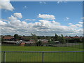
Whiston from Bridge Road
Looking over Whiston from Bridge Road with St Marys & St Pauls C Of E Primary School in the foreground.
Image: © Sue Adair
Taken: 15 Jun 2013
0.07 miles
3
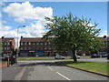
Parade of shops on Molyneux Road from Bryer Road
Image: © Sue Adair
Taken: 15 Jun 2013
0.07 miles
5
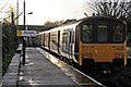
Northern Rail Class 150, 150150, Prescot railway station
The rear of the train is seen departing towards Liverpool, on a service from Wigan.
Image: © El Pollock
Taken: 30 Dec 2013
0.24 miles
6
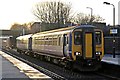
Northern Rail Class 156, 156466, Prescot railway station
The train arrives with a service from Liverpool to Wigan.
Image: © El Pollock
Taken: 30 Dec 2013
0.25 miles