IMAGES TAKEN NEAR TO
Coverdale Avenue, PRESCOT, L35 4NJ
Introduction
This page details the photographs taken nearby to Coverdale Avenue, L35 4NJ by members of the Geograph project.
The Geograph project started in 2005 with the aim of publishing, organising and preserving representative images for every square kilometre of Great Britain, Ireland and the Isle of Man.

There are currently over 7.5m images from over14,400 individuals and you can help contribute to the project by visiting https://www.geograph.org.uk
Image Map
Images are licensed for reuse under creativecommons.org/licenses/by-sa/2.0
Notes
- Clicking on the map will re-center to the selected point.
- The higher the marker number, the further away the image location is from the centre of the postcode.
Image Listing (6 Images Found)
Images are licensed for reuse under creativecommons.org/licenses/by-sa/2.0
Image
Details
Distance
2
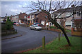
Alness Drive, Rainhill
Semi-detached houses seen from Warrington Road.
Image: © Stephen McKay
Taken: 2 Dec 2012
0.19 miles
3

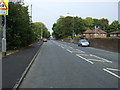
Warrington Road, Rainhill
A brightly-clad cyclist heads towards the centre of Rainhill on a dull - but cold - Sunday morning.
Image: © Stephen McKay
Taken: 2 Dec 2012
0.19 miles
4
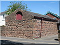
Old Sandstone Building
Old sandstone building on Warrington Road facing Church Place, the original doorway is clearly visible. Its history is unknown but this and the adjacent house were named as Ashfield on the 1907 map although this building appears standing alone on the 1849 map.
Image: © Sue Adair
Taken: 7 May 2017
0.20 miles
5
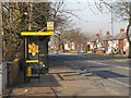
Bus Stop on Warrington Road
Warrington Road (A57), Rainhill.
Image: © David Dixon
Taken: 5 Mar 2013
0.21 miles
6
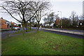
Grass verge by Warrington Road
This is the frontage to a large housing estate to the left.
Image: © Bill Boaden
Taken: 20 Feb 2015
0.24 miles