IMAGES TAKEN NEAR TO
Sherwood Drive, PRESCOT, L35 3XZ
Introduction
This page details the photographs taken nearby to Sherwood Drive, L35 3XZ by members of the Geograph project.
The Geograph project started in 2005 with the aim of publishing, organising and preserving representative images for every square kilometre of Great Britain, Ireland and the Isle of Man.

There are currently over 7.5m images from over14,400 individuals and you can help contribute to the project by visiting https://www.geograph.org.uk
Image Map
Images are licensed for reuse under creativecommons.org/licenses/by-sa/2.0
Notes
- Clicking on the map will re-center to the selected point.
- The higher the marker number, the further away the image location is from the centre of the postcode.
Image Listing (15 Images Found)
Images are licensed for reuse under creativecommons.org/licenses/by-sa/2.0
Image
Details
Distance
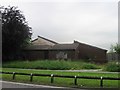
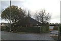
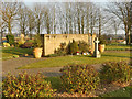
3
Blundells Hill
Over the road are flats and behind the flats is Blundells hill Rainhill
Image: © Sharon Crowther
Taken: 18 Dec 2004
0.10 miles
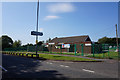
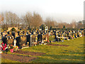
9
Knowsley Cemetery, Garden of Remembrance
The Garden of Remembrance at the cemetery on Fox's Bank Lane, Whiston.
Image: © David Dixon
Taken: 5 Mar 2013
0.22 miles
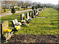
10
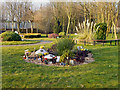
Garden of Remembrance, Knowsley Cemetery
The Garden of Remembrance at the cemetery on Fox's Bank Lane, Whiston.
Image: © David Dixon
Taken: 5 Mar 2013
0.22 miles