IMAGES TAKEN NEAR TO
Windy Arbor Road, PRESCOT, L35 3SQ
Introduction
This page details the photographs taken nearby to Windy Arbor Road, L35 3SQ by members of the Geograph project.
The Geograph project started in 2005 with the aim of publishing, organising and preserving representative images for every square kilometre of Great Britain, Ireland and the Isle of Man.

There are currently over 7.5m images from over14,400 individuals and you can help contribute to the project by visiting https://www.geograph.org.uk
Image Map
Images are licensed for reuse under creativecommons.org/licenses/by-sa/2.0
Notes
- Clicking on the map will re-center to the selected point.
- The higher the marker number, the further away the image location is from the centre of the postcode.
Image Listing (12 Images Found)
Images are licensed for reuse under creativecommons.org/licenses/by-sa/2.0
Image
Details
Distance
1
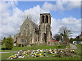
St Nicholas' Church, Whiston
St Nicholas' Church consecrated on 30th July 1868 was originally designed to have a spire on the tower but this could not be carried through due to mining subsidence.
Image: © Sue Adair
Taken: 3 Apr 2006
0.06 miles
2
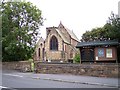
St Nicholas church in Windy Arbour Road
Image: © Raymond Knapman
Taken: 26 Aug 2010
0.12 miles
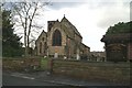
4

Church of St Nicholas, Whiston
The Church of St Nicholas in Windy Arbor Road was designed by G.E. Street and built in 1864–68. The tower was never completed because of a fear of subsidence from local coal mining.
Image: © Sue Adair
Taken: 11 Aug 2018
0.14 miles
6
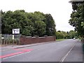
Windy Arbour Road bridge over the trackbed of Cronton Colliery railway
The railway once ran from the colliery to Huyton Quarry
Image: © Raymond Knapman
Taken: 26 Aug 2010
0.15 miles
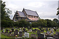
7

War Memorial St.Nicholas' Parish Church
The war memorial dedicated to the men of Whiston who gave their lives in the two world wars is sited within the churchyard of St.Nicholas' Parish Church.
Image: © Sue Adair
Taken: 11 Aug 2018
0.15 miles
10
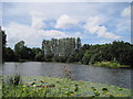
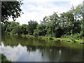
Big Water, Halsnead Park
Big Water, the lake in Halsnead Park, originally the Halsnead Estate, the hall of which was built by Thomas Willis in 1694.
Image: © Sue Adair
Taken: 20 Jul 2009
0.24 miles