IMAGES TAKEN NEAR TO
Orchard Close, PRESCOT, L35 3RJ
Introduction
This page details the photographs taken nearby to Orchard Close, L35 3RJ by members of the Geograph project.
The Geograph project started in 2005 with the aim of publishing, organising and preserving representative images for every square kilometre of Great Britain, Ireland and the Isle of Man.

There are currently over 7.5m images from over14,400 individuals and you can help contribute to the project by visiting https://www.geograph.org.uk
Image Map
Images are licensed for reuse under creativecommons.org/licenses/by-sa/2.0
Notes
- Clicking on the map will re-center to the selected point.
- The higher the marker number, the further away the image location is from the centre of the postcode.
Image Listing (6 Images Found)
Images are licensed for reuse under creativecommons.org/licenses/by-sa/2.0
Image
Details
Distance
1
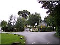
Entrance to Halsnead Park Caravan Park
Image: © Raymond Knapman
Taken: 26 Aug 2010
0.04 miles
2
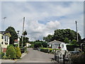
Halsnead Caravan Park
Halsnead Hall was built of red sandstone by Thomas Willis in 1684. It was sold in 1929 and demolished in 1932. The huge wooded estate known as Halsnead Park was unsuitable for building houses due to mining subsidence from the nearby Cronton colliery so part of the park was converted into a static caravan park. Now the home of many retired people, the open views, community spirit and well tended gardens make it a very pleasant place to live.
Image: © Sue Adair
Taken: 20 Jul 2009
0.08 miles
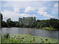
3
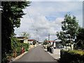
Halsnead Park
Residential caravan park in Halsnead Park.
Image: © Sue Adair
Taken: 20 Jul 2009
0.13 miles
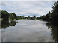
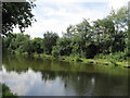
5
Big Water, Halsnead Park
Big Water, the lake in Halsnead Park, originally the Halsnead Estate, the hall of which was built by Thomas Willis in 1694.
Image: © Sue Adair
Taken: 20 Jul 2009
0.20 miles