IMAGES TAKEN NEAR TO
Dryden Close, PRESCOT, L35 2YL
Introduction
This page details the photographs taken nearby to Dryden Close, L35 2YL by members of the Geograph project.
The Geograph project started in 2005 with the aim of publishing, organising and preserving representative images for every square kilometre of Great Britain, Ireland and the Isle of Man.

There are currently over 7.5m images from over14,400 individuals and you can help contribute to the project by visiting https://www.geograph.org.uk
Image Map
Images are licensed for reuse under creativecommons.org/licenses/by-sa/2.0
Notes
- Clicking on the map will re-center to the selected point.
- The higher the marker number, the further away the image location is from the centre of the postcode.
Image Listing (14 Images Found)
Images are licensed for reuse under creativecommons.org/licenses/by-sa/2.0
Image
Details
Distance
1
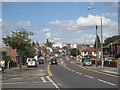
Dragon Drive
Dragon Drive straightened Dragon Lane, the original thoroughfare, for modern traffic. Whiston Hospital can be seen in the distance.
Image: © Sue Adair
Taken: 16 Aug 2012
0.10 miles
2

Youatt Avenue - Flower planting on the green
Local residents helping to brighten up the green!
Image: © Jay Battersby
Taken: 5 May 2006
0.18 miles
4
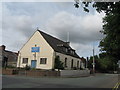
Whiston Methodist Church
This builder's at the corner of Dragon Lane and Cross Lane was previously Whiston Methodist Church. One of three Methodist chapels in the area, a traditional Wesleyan Methodist Chapel erected in 1832, followed by a Free United Methodist Chapel in 1879, and later a Welsh Methodist Chapel in 1890 to provide a place of worship for the families of the Welsh miners who had settled in Whiston in large numbers.
A new chapel has been built adjacent to the original building.
Image: © Sue Adair
Taken: 19 Jul 2009
0.22 miles
5
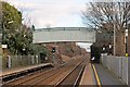
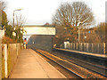
Footbridge, Whiston railway station
Situated at the eastern end of the station, signal HN314 is beneath the bridge.
Image: © El Pollock
Taken: 17 Jan 2014
0.22 miles
6
Whiston Railway Station
Looking along the platform towards the footbridge over the line at Whiston Station.
Image: © David Dixon
Taken: 5 Mar 2013
0.23 miles
7
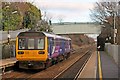
Northern Rail Class 142, 142057, Whiston railway station
The train departs with a service from Liverpool, to either Manchester or Warrington.
Image: © El Pollock
Taken: 17 Jan 2014
0.23 miles
8
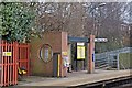
Waiting shelter, Whiston railway station
The shelter is situated on the Manchester-bound platform.
Image: © El Pollock
Taken: 17 Jan 2014
0.24 miles
9
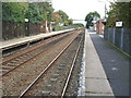
Whiston railway station, Merseyside
Opened in 1990 by British Rail on the line from Liverpool to Manchester via Earlestown.
View east towards Lea Green and Earlestown before the line was electrified. For a similar view from the opposite platform six years later, see Image
Image: © Nigel Thompson
Taken: 17 Oct 2009
0.24 miles
10
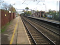
Whiston railway station, Merseyside
Opened in 1990 by British Rail on the line from Liverpool to Manchester via Earlestown.
View east towards Lea Green and Earlestown shortly after the line was electrified. For a similar view six years earlier from the opposite platform, see Image
Image: © Nigel Thompson
Taken: 10 Nov 2015
0.24 miles