IMAGES TAKEN NEAR TO
Byron Avenue, PRESCOT, L35 2YD
Introduction
This page details the photographs taken nearby to Byron Avenue, L35 2YD by members of the Geograph project.
The Geograph project started in 2005 with the aim of publishing, organising and preserving representative images for every square kilometre of Great Britain, Ireland and the Isle of Man.

There are currently over 7.5m images from over14,400 individuals and you can help contribute to the project by visiting https://www.geograph.org.uk
Image Map
Images are licensed for reuse under creativecommons.org/licenses/by-sa/2.0
Notes
- Clicking on the map will re-center to the selected point.
- The higher the marker number, the further away the image location is from the centre of the postcode.
Image Listing (4 Images Found)
Images are licensed for reuse under creativecommons.org/licenses/by-sa/2.0
Image
Details
Distance
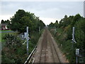
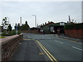
2
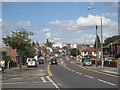
Dragon Drive
Dragon Drive straightened Dragon Lane, the original thoroughfare, for modern traffic. Whiston Hospital can be seen in the distance.
Image: © Sue Adair
Taken: 16 Aug 2012
0.16 miles
3
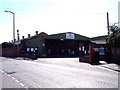
Factory entrance off Stoney Lane
The ex Stove's factory remains in business
Image: © Raymond Knapman
Taken: 31 Aug 2010
0.22 miles