IMAGES TAKEN NEAR TO
Cronton Road, PRESCOT, L35 1QR
Introduction
This page details the photographs taken nearby to Cronton Road, L35 1QR by members of the Geograph project.
The Geograph project started in 2005 with the aim of publishing, organising and preserving representative images for every square kilometre of Great Britain, Ireland and the Isle of Man.

There are currently over 7.5m images from over14,400 individuals and you can help contribute to the project by visiting https://www.geograph.org.uk
Image Map
Images are licensed for reuse under creativecommons.org/licenses/by-sa/2.0
Notes
- Clicking on the map will re-center to the selected point.
- The higher the marker number, the further away the image location is from the centre of the postcode.
Image Listing (14 Images Found)
Images are licensed for reuse under creativecommons.org/licenses/by-sa/2.0
Image
Details
Distance
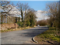
1
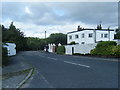
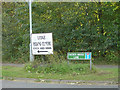
Entrance to the former Cronton Colliery site
Image: © Peter Bond
Taken: 30 Apr 2013
0.01 miles
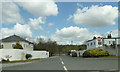
2
Cronton Colliery Entrance
One of a pair of entrances to the former colliery site from Cronton Road, which must originally have been operated as a one way system, judging by the no entry sign. If this is still enforceable, the inhabitants of the house are technically in breach of it every time they drive home!
Image: © Alan Murray-Rust
Taken: 3 Oct 2008
0.02 miles
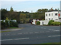
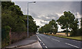
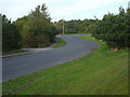
3
A5080 at Cronton
Passing the entrances to the former Cronton Colliery. The road has been improved from how I remember it before the M62 was built.
Image: © Alan Murray-Rust
Taken: 3 Oct 2008
0.03 miles
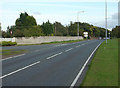
5
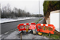
Closed footpath by the A5080
The footpath has been closed on this side for tree-trimming.
Image: © Bill Boaden
Taken: 31 Jan 2019
0.06 miles
7
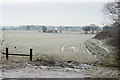
Frozen fields near Cronton
Looking south from the A5080.
Image: © Bill Boaden
Taken: 31 Jan 2019
0.12 miles
8
Sign for Dacres Bridge Lane
Although the bridge itself is named Daggers Bridge Image
Image: © Alan Murray-Rust
Taken: 3 Oct 2008
0.13 miles
9
Junction of Dacres Bridge Lane and the A5080
The road in the foreground was the old A5080 which was realigned following the construction of the M62.
Image: © Alan Murray-Rust
Taken: 3 Oct 2008
0.13 miles