IMAGES TAKEN NEAR TO
Harrison Way, LIVERPOOL, L3 4BG
Introduction
This page details the photographs taken nearby to Harrison Way, L3 4BG by members of the Geograph project.
The Geograph project started in 2005 with the aim of publishing, organising and preserving representative images for every square kilometre of Great Britain, Ireland and the Isle of Man.

There are currently over 7.5m images from over14,400 individuals and you can help contribute to the project by visiting https://www.geograph.org.uk
Image Map
Images are licensed for reuse under creativecommons.org/licenses/by-sa/2.0
Notes
- Clicking on the map will re-center to the selected point.
- The higher the marker number, the further away the image location is from the centre of the postcode.
Image Listing (73 Images Found)
Images are licensed for reuse under creativecommons.org/licenses/by-sa/2.0
Image
Details
Distance
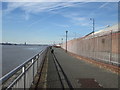
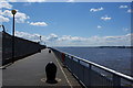
2
Riverside path by the Mersey
Part of the Transpennine Trail passing Brunswick Business Park on the left.
Image: © Bill Boaden
Taken: 23 Mar 2019
0.02 miles
3
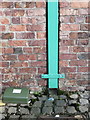
Bench mark on the former warehouse in Atlantic Way
This warehouse was built in 1887 between the River Mersey and Toxteth Dock. In 1987 the Brunswick Business Park was created and the warehouse was refurbished into business units. The Ordnance Survey bench mark on the right of the drainpipe is recorded on the 1890 O.S. map. See also Image
Image: © John S Turner
Taken: 28 Jan 2016
0.03 miles
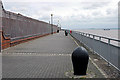
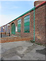
4
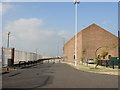
Brunswick Dock
Business premises in the 19th Century dock buildings facing the Mersey. The Transpennine trail running along the left-hand side of the picture behind the railings has spectacular views of the waterfront and over the Mersey to the Wirral and North Wales beyond.
Image: © Sue Adair
Taken: 27 Oct 2005
0.03 miles
5
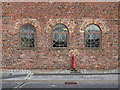
Three windows in the former Toxteth Dock warehouse
This 1887 warehouse faces the River Mersey behind the camera, and the former Toxteth Dock along the other side. The building was converted into business premises in 1987 and Toxteth Dock was filled in.
Image: © John S Turner
Taken: 28 Jan 2016
0.04 miles
6
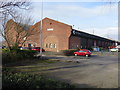
Warehouse/business premises alongside the in-filled Toxteth Dock
This building was a warehouse built in 1887 and then converted to business premises in 1987 - the two dates are above the arched in-filled gable end. The former Toxteth Dock was on the right, where the cars are parked, but was filled in when the Brunswick Business Park was created. The photo was taken from Harrison Way.
Image: © John S Turner
Taken: 28 Jan 2016
0.04 miles
8
The former warehouse alongside Atlantic Way
This warehouse was built in 1887 between the River Mersey and Toxteth Dock. In 1987 the Brunswick Business Park was created, Toxteth Dock was in-filled, and the warehouse was refurbished into business units. In 2016 this unit is occupied by Saville Audio Visual, and there is an Ordnance Survey bench mark on the right of the green drainpipe. The cut mark is recorded on the 1890 O.S. map - see Image
Image: © John S Turner
Taken: 28 Jan 2016
0.05 miles
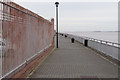
9
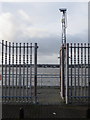
Gateway from Atlantic Way to the riverside promenade
This gateway provides access from the Brunswick Business Park to the riverside promenade alongside the River Mersey.
Image: © John S Turner
Taken: 28 Jan 2016
0.06 miles