IMAGES TAKEN NEAR TO
School Lane, PRESCOT, L34 9JG
Introduction
This page details the photographs taken nearby to School Lane, L34 9JG by members of the Geograph project.
The Geograph project started in 2005 with the aim of publishing, organising and preserving representative images for every square kilometre of Great Britain, Ireland and the Isle of Man.

There are currently over 7.5m images from over14,400 individuals and you can help contribute to the project by visiting https://www.geograph.org.uk
Image Map
Images are licensed for reuse under creativecommons.org/licenses/by-sa/2.0
Notes
- Clicking on the map will re-center to the selected point.
- The higher the marker number, the further away the image location is from the centre of the postcode.
Image Listing (8 Images Found)
Images are licensed for reuse under creativecommons.org/licenses/by-sa/2.0
Image
Details
Distance
1
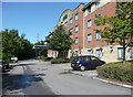
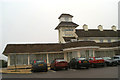
The Holiday Inn, Ribbler's Lane, Knowsley
Much cheaper that the one at the Albert Dock.
Image: © Humphrey Bolton
Taken: 9 Sep 2017
0.03 miles
2
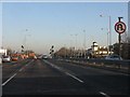
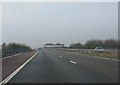
A580 nearing the A5207 junction
Neither right turns nor "U" turns are permitted from the eastbound A580 at the junction ahead.
Image: © Peter Whatley
Taken: 17 Jan 2012
0.10 miles
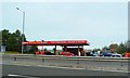
3

A cluster of hotels on the East Lancashire Road
Including the light coloured building as the Knowsley Suites hotel.
Image: © Steve Fareham
Taken: 9 Mar 2010
0.11 miles
5
Moorgate Lane roundabout with M57 bridge above
Image: © Colin Pyle
Taken: 14 Aug 2010
0.14 miles
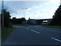
6
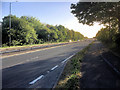
East Lancashire Road (A580), Knowsley
Looking west (towards Liverpool) along the East Lancashire Road at Knowsley.
Image: © David Dixon
Taken: 8 May 2017
0.18 miles
7
M57 at junction 4
The parapets are for the northernmost of the two roundabout bridges.
Image: © Peter Whatley
Taken: 23 Mar 2012
0.19 miles
8
Where once stood the Cherry Tree
The Cherry Tree pub was once a very prominent feature of the nearby junction of the A580 at Kirkby. It was a well-known fare-stage on the Liverpool tram route which ran through this spot to the former wartime munitions factory nearby.
Image: © David Long
Taken: 22 Nov 2005
0.25 miles