IMAGES TAKEN NEAR TO
Lockton Road, PRESCOT, L34 9GP
Introduction
This page details the photographs taken nearby to Lockton Road, L34 9GP by members of the Geograph project.
The Geograph project started in 2005 with the aim of publishing, organising and preserving representative images for every square kilometre of Great Britain, Ireland and the Isle of Man.

There are currently over 7.5m images from over14,400 individuals and you can help contribute to the project by visiting https://www.geograph.org.uk
Image Map
Images are licensed for reuse under creativecommons.org/licenses/by-sa/2.0
Notes
- Clicking on the map will re-center to the selected point.
- The higher the marker number, the further away the image location is from the centre of the postcode.
Image Listing (6 Images Found)
Images are licensed for reuse under creativecommons.org/licenses/by-sa/2.0
Image
Details
Distance
1
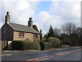
Chapel Cottage, School Lane, Knowsley
Chapel Cottage on School Lane, Knowsley, the date on the sandstone lintel above the door says 1770
Image: © Sue Adair
Taken: 21 Feb 2006
0.07 miles
3
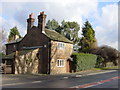
Quarry Cottage, School Lane, Knowsley
Quarry Cottage on School Lane, Knowsley, looks like an idyllic country retreat, in fact it is surrounded by industrial units of Knowsley Industrial Estate along with neighbouring Chapel Cottage.
Image: © Sue Adair
Taken: 21 Feb 2006
0.09 miles
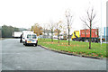
5
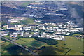
Knowsley Business Park from the air
Taken from a plane on approach to Liverpool John Lennon Airport.
Image: © Mike Pennington
Taken: 5 Jul 2016
0.12 miles