IMAGES TAKEN NEAR TO
Marlborough Road, PRESCOT, L34 6LE

Introduction

This page details the photographs taken nearby to Marlborough Road, L34 6LE by members of the Geograph project.

The Geograph project started in 2005 with the aim of publishing, organising and preserving representative images for every square kilometre of Great Britain, Ireland and the Isle of Man.

There are currently over 7.5m images from over14,400 individuals and you can help contribute to the project by visiting https://www.geograph.org.uk

Image Map


Images are licensed for reuse under creativecommons.org/licenses/by-sa/2.0
Notes
  • Clicking on the map will re-center to the selected point.
  • The higher the marker number, the further away the image location is from the centre of the postcode.

Image Listing (24 Images Found)

Images are licensed for reuse under creativecommons.org/licenses/by-sa/2.0
  • ...
Image
Details
Distance
1
Cross Street, Prescot
Image: © Alexander P Kapp Taken: 28 Mar 2011
0.10 miles
2
Disused water tower
Image: © Mr M Evison Taken: 14 May 2006
0.14 miles
3
St Helens Road, Prescot
Image: © Alexander P Kapp Taken: 28 Mar 2011
0.15 miles
4
Dis-used water tower northside of St Helens Road
Image: © Alexander P Kapp Taken: 28 Mar 2011
0.15 miles
5
Old Gents, Grosvenor Road, Prescot
Writing on the wall.
Image: © John Kelly Taken: 19 Apr 2021
0.16 miles
6
War Memorial, Prescot
Situated at the corner of St Helens Road and Burrows Lane, Prescot, opposite the Wellington pub.
Image: © Sue Adair Taken: 24 Aug 2005
0.18 miles
7
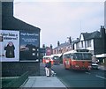
Two Buses in Prescot
Taken in March 1971, this photo shows two AEC Swift vehicles with Marshall 44-seater bodywork operated by St Helens Corporation Transport in Warrington Road (A57). The front vehicle is 222 (RDJ 222F) on St Helens circular route 8 via Prescot and Rainhill. This route was operated by trolleybuses until the closure of the St Helens trolleybus system on the 30th June 1958. A lamp standard which was used for trolleybus overhead wiring can be seen between the two vehicles, although these standards have long since been replaced by modern lighting standards.
Image: © David Hillas Taken: 27 Mar 1971
0.19 miles
8
On St Helens Road, Prescot
Image: © Neil Theasby Taken: 12 Sep 2016
0.19 miles
9
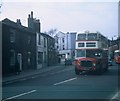
A Double-decker Bus in Prescot
Taken in March 1971, this photo shows a 1962 AEC Regent V No36 (SDJ 356) operated by St Helens Corporation Transport and is shown in Prescot working on route 97 to Moss Bank via Cross Lane. It has Metro-Cammell 64-seater bodywork recognisable by its rectangular air-vent on its front upper dome. The bus undertaking became part of the Merseyside Passenger Transport Executive on 1st April 1974. Arriva North West now operate most of the bus services in this area.
Image: © David Hillas Taken: 27 Mar 1971
0.19 miles
10
The Hare and Hounds or Tommy Halls
The Hare and Hounds has been known as "Tommy Halls" for at least half a century but has recently had a facelift, a new coat of paint, a formal sign "The Thomas Hall" and the restoration of the previous Knotty Ash Ales facia, which is purely decorative as Joseph Jones hasn't brewed since 1928! Adjacent to the old pub stood the Ebenezer Chapel built in 1811 which later moved to a new church and from 1908 this site became the Welsh Congregational Chapel until its demolition in 1970 leaving the small garden which is there today.
Image: © Sue Adair Taken: 13 May 2020
0.20 miles
  • ...