1
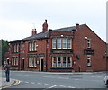
The Eagle and Child, Warrington Road
The Eagle and Child public house on the corner of Warrington Road and Scotchbarn Lane not long after it closed in 2007. The name Eagle and Child stems from the crest of the Stanley family, the Earls of Derby, much associated with this area. In 1385, Isabella de Lathom married Thomas Stanley and following this marriage, the Stanley family adopted the 'eagle and child' crest of the Lathom family and continue to use it to this day.
Image: © Sue Adair
Taken: 12 May 2007
0.10 miles
2
Scotchbarn Leisure Centre - all boarded up
Your intrepid photographer, braving all weathers, manages to get into this shot!
Image: © Ian Greig
Taken: 29 Dec 2011
0.12 miles
3
The Bath Springs, Prescot
The Bath Springs at 103 Kemble Street is a former public house (currently closed).
Image: © David Dixon
Taken: 21 May 2015
0.13 miles
4
The Royal Oak, Prescot
Image: © Chris Whippet
Taken: 26 Jul 2010
0.16 miles
5
Charter train heads towards Eccleston Park station
Diesel locomotive Class 66/0 number 66138 heads the UK Railtours Olive Branch 2 charter towards the Ribble Steam Railway at Preston having visited the Seaforth Dock (Bootle) branch.
Image: © Roger Templeman
Taken: 14 Apr 2012
0.18 miles
6
Railway cutting north east of Scotchbarn Lane
Image: © Nigel Thompson
Taken: 10 Nov 2015
0.19 miles
7
Zion Independent Methodist Church
This building, on Kemble Street, was previously used as a library.
Image: © David Dixon
Taken: 21 May 2015
0.20 miles
8
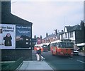
Two Buses in Prescot
Taken in March 1971, this photo shows two AEC Swift vehicles with Marshall 44-seater bodywork operated by St Helens Corporation Transport in Warrington Road (A57). The front vehicle is 222 (RDJ 222F) on St Helens circular route 8 via Prescot and Rainhill. This route was operated by trolleybuses until the closure of the St Helens trolleybus system on the 30th June 1958. A lamp standard which was used for trolleybus overhead wiring can be seen between the two vehicles, although these standards have long since been replaced by modern lighting standards.
Image: © David Hillas
Taken: 27 Mar 1971
0.20 miles
9
Prescot, Station Road
Rows of terraced houses leading down to the site of the former Prescot Cables works (now The Cables Retail Park).
Image: © David Dixon
Taken: 21 May 2015
0.23 miles
10
Crown of India, Kemble Street, Prescot
Formerly the Crown public house.
Image: © David Dixon
Taken: 21 May 2015
0.23 miles


