IMAGES TAKEN NEAR TO
Knowsley Lane, PRESCOT, L34 4AH
Introduction
This page details the photographs taken nearby to Knowsley Lane, L34 4AH by members of the Geograph project.
The Geograph project started in 2005 with the aim of publishing, organising and preserving representative images for every square kilometre of Great Britain, Ireland and the Isle of Man.

There are currently over 7.5m images from over14,400 individuals and you can help contribute to the project by visiting https://www.geograph.org.uk
Image Map
Images are licensed for reuse under creativecommons.org/licenses/by-sa/2.0
Notes
- Clicking on the map will re-center to the selected point.
- The higher the marker number, the further away the image location is from the centre of the postcode.
Image Listing (12 Images Found)
Images are licensed for reuse under creativecommons.org/licenses/by-sa/2.0
Image
Details
Distance
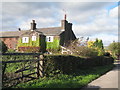
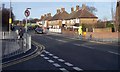
1
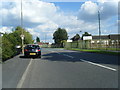
Knowsley Lane
Interesting sign on lamppost pointing way to Safari Park.
Image: © Colin Pyle
Taken: 14 Aug 2010
0.02 miles
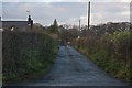
2
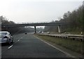
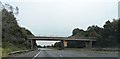
M57 motorway - George Hale Avenue bridge
Image: © Peter Whatley
Taken: 23 Mar 2012
0.13 miles
6
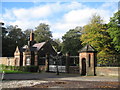
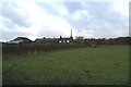
Knowsley Hall Main Gate
This is the gatehouse on The Avenue, the main drive to Knowsley Hall.
Image: © Sue Adair
Taken: 30 Oct 2006
0.17 miles
8

Sunset and nightlight at Knowsley Manor Care Home
Image: © Ian Greig
Taken: 15 Dec 2012
0.20 miles
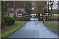
10
Primrose Drive at school time
The junction with Woolfall Heath Avenue
Image: © Raymond Knapman
Taken: 8 Feb 2011
0.20 miles