IMAGES TAKEN NEAR TO
Walnut Grove, L34 3AE
Introduction
This page details the photographs taken nearby to Walnut Grove, L34 3AE by members of the Geograph project.
The Geograph project started in 2005 with the aim of publishing, organising and preserving representative images for every square kilometre of Great Britain, Ireland and the Isle of Man.

There are currently over 7.5m images from over14,400 individuals and you can help contribute to the project by visiting https://www.geograph.org.uk
Image Map
Images are licensed for reuse under creativecommons.org/licenses/by-sa/2.0
Notes
- Clicking on the map will re-center to the selected point.
- The higher the marker number, the further away the image location is from the centre of the postcode.
Image Listing (6 Images Found)
Images are licensed for reuse under creativecommons.org/licenses/by-sa/2.0
Image
Details
Distance
1
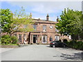
Clock Face Public House, Prescot
The Clock Face Public House on Derby Street, Prescot.
Image: © Sue Adair
Taken: 1 Jun 2006
0.10 miles
2
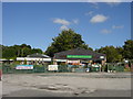
Whittaker's Nursery, Liverpool Road, Prescot
Whittaker's Nursery (garden centre) has stood on this site for a number of years surrounded by the fields of Lord Derby's estate before the Prescot by-pass was constructed.
Image: © Sue Adair
Taken: 24 Aug 2005
0.10 miles
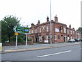
4
Approach to junction 2 on the M57 at Prescot
Image: © Raymond Knapman
Taken: 27 Feb 2015
0.17 miles

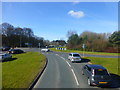
6
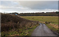
Paddock Road
From here you can see the backs of signs facing on to the M57 motorway
Image: © Ian Greig
Taken: 15 Dec 2012
0.21 miles